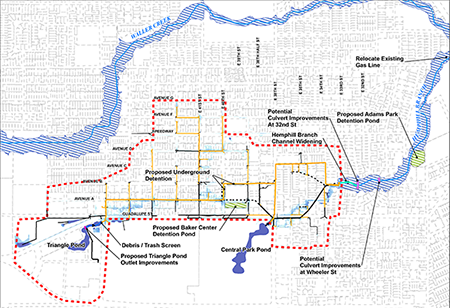
This project will improve the storm drain system near Avenue A in the Hyde Park and North University neighborhoods and reduce the risk of flooding. General project boundaries are Avenue D, W. 33rd St., Guadalupe St. and W. 47th St.
Adams-Hemphill Neighborhood Park
Overview of Guadalupe St. Flood Risk Reduction Project
The type of flooding that is occurring in the project area is known as local flooding. It generally occurs away from creeks in areas where the manmade drainage system of pipes and ditches is overwhelmed by heavy rainfall. In this case, when the neighborhood was developed, we suspect that an entire creek or small tributary was diverted into the storm drain system and roads and possibly structures were built where the water once flowed.
Project Map
The map below is turned on its side with north towards the left. It shows the proposed solution. Click on the map to download a larger PDF.
Proposed Solution
Currently we estimate 224 buildings are at risk of flooding with 9 inches of rain in 24 hours (25-year storm). With the proposed solution, we estimate that 178 of those buildings would no longer flood with that much rain. With 12.3 inches of rain in 24-hours (100-year storm), we estimate 118 buildings would no longer flood.
The proposed solution includes:
- Upgrading 20,000 feet of storm drain pipes
- Optimizing the outfall of the Triangle Pond and its two main headwalls
- Adding debris blockers at the Triangle Pond outfall
- Widening the channel of Hemphill Branch (the creek) at the outfall
- Acquiring easements along an existing pipe
- Relocating underground utilities as needed.
- Improvements to water and wastewater lines.
To prevent worsening flooding along Hemphill Branch, the proposal also includes the following:
- Adding a detention pond in the field next to the Baker Center
- Adding underground detention
- Adding two detention basins in the grassy areas of Adams-Hemphill Neighborhood Park and developing a park concept plan.
- Relocating a gas line near E. 26th Street
- Possibly replacing the culverts at 32nd and Wheeler Streets.
Timeline and Cost
Our capital improvement projects take many years from start to finish. The process typically includes the following phases:
- Preliminary Engineering – when a solution is identified and costs are estimated.
- Design – when the details are worked out and construction plans drawn up.
- Bidding and Permitting – when a contractor is hired and all permits are acquired.
- Construction – when the project is built.
The project is currently in the design phase. Due to the increasing complexity and cost of the project, we are considering dividing construction into multiple phases. The phasing plan is not fully developed, but the downstream portion of a drainage project is always constructed first. For this project, that means the southernmost parts of the project near Adams-Hemphill Neighborhood Park. We do not anticipate allocating funding for construction sooner than 2028, although we will continue to look for grant funding.
The estimated cost is $74,730,000.
Documents
- Presentation from 10/4/21 meetings
- 33rd Street bridge renderings
- Baker Center - fencing options for pond
- Presentation from 11/5/18 meeting
- Presentation from 10/26/17 meeting
Email Updates
Email Stephanie Lott to receive email updates about the project.
Contacts
- Hanh Thai, P.E., 512-974-9232, or send an email to Hanh Thai.

