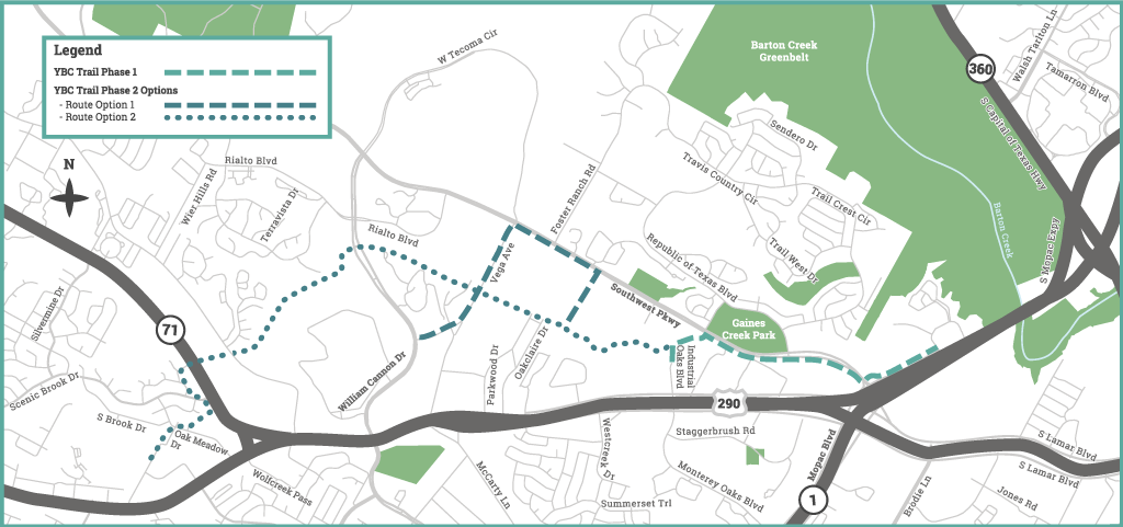
The recommended YBC (Y at Oak Hill to Barton Creek) Trail would be located between the west side of the MoPac Mobility Bridges and the Austin Community College Pinnacle Campus, connecting destinations and neighborhoods along the way.
Project Limits

Project Background
The YBC Trail was originally envisioned during the Oak Hill Neighborhood Planning process. Trail enthusiasts and neighbors came together to create a vision for a trail system that would connect much of the Oak Hill and Barton Creek areas of Austin to Downtown Austin.
Project Process
Public Meetings
From July 2015 through December 2016 the project team hosted five planning meetings. These were followed with a month-long online voting period used to gather public feedback on several route options. Feedback from these meetings helped inform the project’s Preliminary Engineering Report.
Preliminary Engineering Report
The Urban Trails Program released a Preliminary Engineering Report in 2017. This report shows the recommended route for the YBC trail. It also lists topics that the City needs to consider to build this trail, such as environmental concerns, wildlife, and nearby property ownership. See the YBC Trail preliminary engineering report here.
YBC Trail Phase 1: Updates and Next Steps
The first phase of YBC Trail would include a 1.65-mile trail from the MoPac and Gaines Ranch Loop intersection to the Industrial Oaks Blvd and Gaines Creek Tributary intersection. With funds from the 2016 Mobility Bond, this project has reached 30% design. However, the Urban Trails Program is placing further design on hold while reviewing options to address newly identified project considerations.
Project Considerations
During the project’s design phase, the team identified additional challenges that would significantly increase the project’s cost. These include environmental constraints near the proposed route, such as newly formed sinkholes, requiring additional infrastructure like extensive bridging, and necessary environmental reviews and approvals.
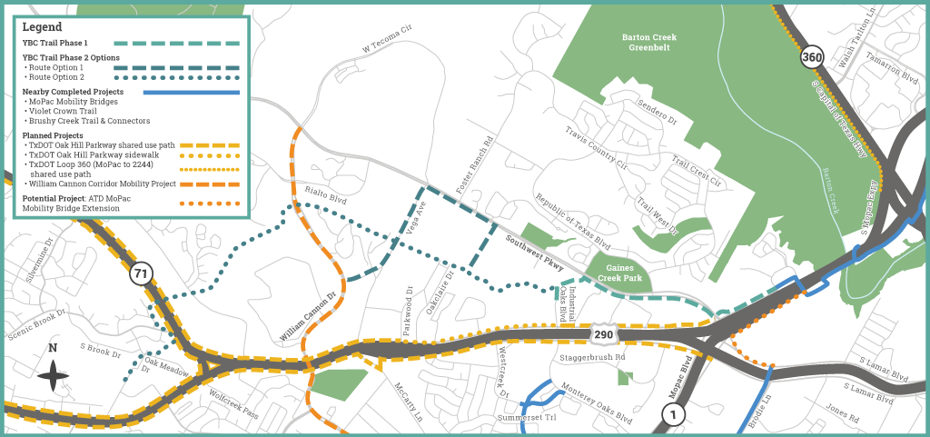
The Urban Trails Program is also reevaluating connectivity needs along the MoPac corridor due to other projects in the area through our partners at the Texas Department of Transportation (TxDOT) and the Austin Transportation Department (ATD). See the map below for completed, planned, and potential partner projects closest to the YBC Trail project area.

TxDOT’s Oak Hill Parkway Project will include a shared use path to increase east to west connectivity for people walking and people on bikes. The Oak Hill Parkway Project is anticipated to break ground midyear 2021, and construction is expected to last for five years. Additionally, ATD is reviewing options to extend shared use paths from the south end of the MoPac Mobility Bridges. For these reasons, the Urban Trails Program is reviewing more efficient, impactful ways to improve connectivity both along MoPac and citywide.
Next Steps
While we continue exploring potential options for YBC Trail, the Urban Tails Program is looking at smaller improvements to make it easier and safer to walk and bike in this area. No funding is currently identified for these smaller improvements.
Get Involved!
Contact Us
Email MobilityBonds@austintexas.gov to:
- Submit questions and comments about this project
- Request a presentation from the project team for your group or organization
Stay Updated
Subscribe to Austin Mobility News for a weekly digest of urban trails and other mobility-related projects and programs.

