
Urban Trails Plan
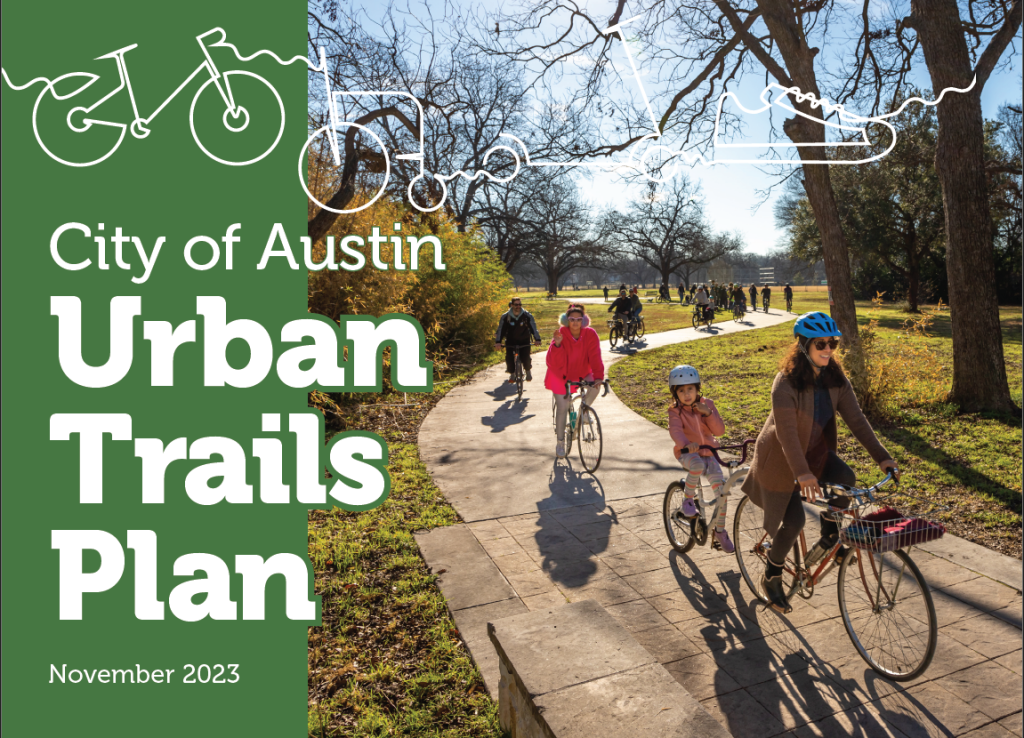
Table of Contents
- Executive Summary
- Introduction
- Network Updates and Prioritization
- Implementation Plan
- Managing and Maintaining a World Class Network
- Appendices
- Appendix A: ATX Walk Bike Roll Process Summary
- Appendix B: Urban Trail Network Field Work Report
- Appendix C: Urban Trail Network Maps, Scenarios, and Prioritization
- Appendix D: Urban Trails Design Guidance
- Appendix E: Shared Use Corridors White Paper
- Appendix F: Feasibility Assessment
- Appendix G: Maintenance Policy and Processes
Disclaimer: Information contained in this document is for planning purposes and should not be used for final design of any project. All results, recommendations, and commentary contained herein are based on limited data and information and on existing conditions that are subject to change. Existing conditions have not been field-verified. Further analysis and engineering design are necessary prior to implementing any of the recommendations contained herein.
Executive Summary
Trails are all about making connections. They connect us to the places we need to go and with the natural world. They are also a space for us to connect with friends and family. They serve as a serene and quiet place for some, and for others they are the backdrop for adventure and discovery. The connections we make on and through trails—to our shared history, to new opportunities, and to each other—are at the heart of this 2023 update to the City of Austin’s Urban Trails Plan.
Purpose of the Plan
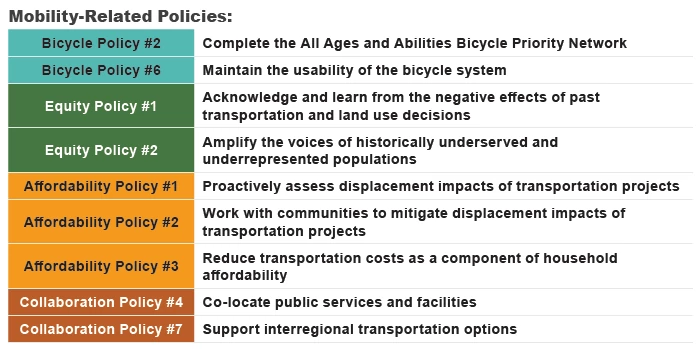
The Urban Trails Plan (Plan) is a guiding document that recommends key next steps for building, maintaining, and managing Austin’s urban trail system in an effort to create a world-class trail system. The Plan envisions a system of urban trails that equitably connects all of Austin so that people of all ages, abilities, and backgrounds can travel from one end of the city to another in a safe and healthy way. A successful urban trail system becomes part of Austinites’ daily life – from taking an urban trail to pick-up kids from school, make a run to a grocery store, or to go for a walk or bike ride to a nearby park for exercise or fun. Urban trails expand Austin’s outdoor recreational opportunities and make it easier for people of all abilities to get outside, exercise, and connect with nature and their community. Many of Austin’s urban trails improve access to natural areas like creeks, greenbelts, and parks. They also act as scenic corridors through which residents can explore nearby neighborhoods, learn about historic sites, and enjoy art and cultural landmarks. Urban trails also serve as a key part of the transportation network, working in conjunction with the on-street pedestrian and bicycle networks to help achieve the Austin Strategic Mobility Plan (ASMP) goal of reaching 50-50 modal split by 2039. This aggressive goal calls for 50 percent of all trips taken by 2039 to be made by walking, biking, transit, and carpool/taxicab and 50 percent by driving alone. This Plan is rooted in the ASMP which established three policies specifically related to urban trails. These three policies shaped the development of the goals and action items recommended in the Plan.
ASMP Urban Trails Policies
Urban Trails Policy 1: Recognize the Urban Trail System as an integral part of the transportation network.
- Acknowledge urban trails as assets that should be constructed, operated, and maintained in a manner equivalent to other parts of the transportation network
Urban Trails Policy 2: Provide high quality Urban Trails that can serve all users.
- Implement a system of Urban Trails designed for people of all ages, abilities, and backgrounds
Urban Trails Policy 3: Pursue opportunities to connect to and expand the Urban Trails System.
- Expand the urban trail system to connect more people to nature and provide recreation and mobility opportunities
What are Urban Trails?
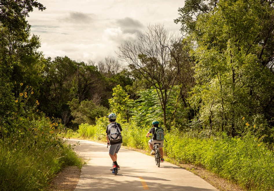
Urban trails are wide, paved, multi-use trails that connect with on-street bikeways and sidewalks. Urban trails are physically separated from motor vehicles and
used as recreational and transportation routes by people walking, biking, rolling, and more.
What Makes a Trail System World-Class?
- Developing a high-quality trail network that is legible, continuous, direct, comfortable, and convenient.
- Fostering a robust culture of trail use through programming.
- Maintaining the trail system as key transportation infrastructure.
Building a World Class Urban Trail System
For the urban trails system to do its part in achieving the ASMP vision, the City of Austin must aspire to implement a world-class urban
trail system. This can be done by implementing the three ASMP policies directly relating to urban trails as well as other trails-supportive policies. Cities with world-class urban trail systems view trails as essential community infrastructure – they are valued and used for transportation, recreation, maintaining personal health and fitness, and are a place where we enjoy and appreciate the natural environment. Urban trails are seen as essential when local elected officials understand the publics’ demand for more trails; when transportation agencies understand that trails are a vital part of a multimodal transportation system; and when the health care community promotes trail use as an important part of healthy living. In Austin, the Urban Trails Program is responsible for the development and management of Austin’s urban trail system. As such, they provided leadership for this Urban Trails Plan and will take the lead in accomplishing the goals of the Plan.
Equitable Trail Development
A world-class trail system is used and enjoyed by people of all backgrounds, regardless of race, ethnicity, income, or health condition. While this Plan speaks to implementation of an equitable urban trail system, more holistic equitable transportation outcomes can only occur by concurrently addressing Austin’s affordability and displacement crisis. All Austinites, regardless of race and income should be able to live in walking or biking distance to neighborhood destinations and have safe routes to reach these destinations. To achieve this, the city must prioritize integrated housing, land use, and mobility programs and policies.
Urban Trail Network
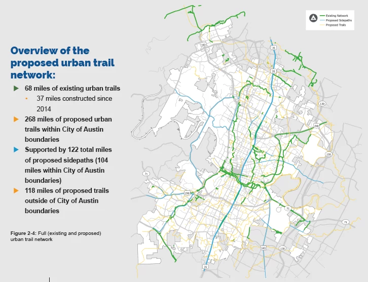
Since the 2014 Urban Trails Plan, the City of Austin has constructed 37 miles of new urban trails, bringing the total existing network up to about 68 miles. The urban trails network proposed in 2014 has been updated in this Plan based on completed fieldwork, removal of redundant segments, and addition of segments by the community through an online input map. The resulting Proposed Urban Trail Network consists of 268 miles of urban trails within the City of Austin (See Page 30 for Proposed Urban Trail Network).
1 ADA stands for The Americans with Disabilities Act. It refers to making public places more accessible for people with disabilities.
To prioritize projects, the City created three scenarios each of which illustrated a different way of prioritizing the Proposed Urban Trail Network. These scenarios were presented to the public to gather input on which type of urban trail projects should be built first. Based on public feedback, established city priorities, staff input, and feasibility, the Proposed Urban Trail Network was divided into three tiers of projects. Ninety-four miles of Urban Trails were identified as Tier 1, or high priority.
Trail Management and Maintenance
To achieve the ASMP policies and create a world-class trail system, the development of a high-quality trail network is needed, but just as important are trail management and maintenance.
Through community outreach, we heard that low-income communities and communities of color do not always feel welcome on Austin’s trails. To ensure urban trails serve all users, the programming strategies discussed in the Plan include recommendations on how to increase the amount and diversity of trail users through placemaking, outreach, and education.
Additionally, for the trail system to serve as an integral part of the transportation network, it needs to be well maintained and free of ADA barriers. This Plan includes an ADA1 transition plan and an outline to support the creation of a proactive urban trail maintenance plan.
These strategies are designed to equitably advance the urban trail system beyond current practices in accordance with the ASMP policies. In order to implement these strategies, additional operational funds and resources are needed.
What we heard
"For my personal walk, I have not found a route that makes me comfortable because even though there are a few Black people, I stick out like a sore thumb and people stare, confused as to why they have to view someone like me.”
- Community Ambassador, Spring 20This Plan recommends how to further these policies through Implementation Strategies (Chapter 3), Trail Management Strategies (Chapter 4), and other sections written to guide the growth of the urban trail system, including:
- Program Goals, and Action Items (page 19)
- Network Map and Prioritization (page 36)
- Feasibility Assessments (page 57)
- Design Guidance (page 51)
- Management and Maintenance Recommendations (Appendix G)
Introduction 1
This chapter defines the role of urban trails in Austin’s active transportation landscape and discusses previous plans and policies that serve as the foundation of the Urban Trails Plan. It then provides an overview of ATX Walk Bike Roll, the City’s process to update Austin’s sidewalk, urban trails, and bicycle plans. Finally, the chapter presents the goals and actions items for the Urban Trails Program.
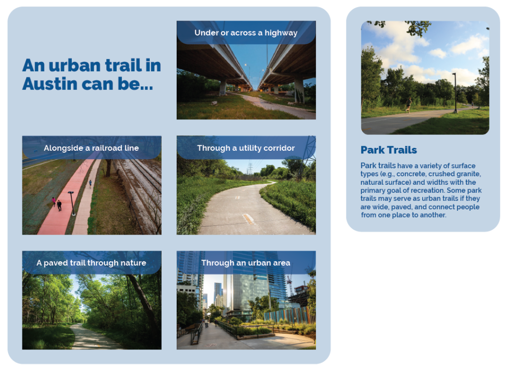
1.1 What is an Urban Trail?
Austin’s urban trails are wide, paved multi-use paths that link our City’s neighborhoods, community resources, and green spaces. They are typically located off-street and are designed to provide a comfortable way to walk, bike, and roll separate from cars. Together with sidewalks and on-street bikeways, they form the City’s active transportation system and are key to providing more affordable, sustainable transportation and recreation options in Austin. Through placemaking, urban trails can also be creative, community-oriented places that are fun to use. Trails can look and feel very different based on their location. In Austin, these facilities are planned, designed, constructed, and managed by the Urban Trails Program in partnership with the Parks and Recreation Department (PARD) and others. This Plan is primarily focused on facilities that are the responsibility of the Urban Trails Program. Figure 1-1 shows some of the many agencies that work on trails and related trail infrastructure.

1.2 Foundation for the Urban Trails Plan
This Urban Trails Plan (Plan) is an update to the 2014 City of Austin Urban Trails Plan. Austin has changed significantly since 2014 and new plans and policies have been adopted. Using the 2014 Urban Trails Plan as a framework, the Plan includes goals and action items rooted in the policies established in the Austin Strategic Mobility Plan (2019). Additionally, the Plan is influenced by the Imagine Austin Comprehensive Plan (2012), Vision Zero Action Plan (2016, update 2021), Our Parks Our Future: Austin Parks and Recreation Long Range Plan (2019), Climate Equity Plan (2021), and Transportation Criteria Manual (update 2022).
ASMP Urban Trails Policies
Urban Trails Policy 1: Recognize the Urban Trail System as an integral part of the transportation network.
- Acknowledge urban trails as assets that should be constructed, operated, and maintained in a manner equivalent to other parts of the transportation network
Urban Trails Policy 2: Provide high quality Urban Trails that can serve all users.
- Implement a system of Urban Trails designed for people of all ages, abilities, and backgrounds
Urban Trails Policy 3: Pursue opportunities to connect to and expand the Urban Trails System.
- Expand the urban trail system to connect more people to nature and provide recreation and mobility opportunities
1.2.1 The Austin Strategic Mobility Plan
The Austin Strategic Mobility Plan (ASMP) is a comprehensive plan that established a vision for Austin’s multimodal transportation network. It calls for decreasing the percent of people who drive alone to work to 50 percent by increasing the percent of people who walk, bike, take transit, carpool, or avoid commuting by working from home to 50 percent. This Urban Trails Plan contributes to that mobility goal by comprehensively planning Austin’s urban trail system as an off-street network that provides another option for how Austinites get around.
The ASMP established three policies specific to urban trails, listed on the previous page. These three policies shaped this Plan, its goals, and action items.
Other ASMP policies that informed or complement the development of this plan include (but are not limited to) the following policies. More information on each of these policies can be found in the Austin Strategic Mobility Plan.
1.2.2 Additional Planning Influences
Additional planning processes and design guidelines influenced this update include:
- Vision Zero Action Plan (2016, 2021 Update): The City of Austin has committed to a goal of having zero traffic-related fatalities in
our community. This plan outlines a set of actionable steps to improve the safety of our transportation network, including prioritizing human life above all else, increasing the safety of pedestrian crossings, and minimizing the potential for conflicts between transportation network users. - Our Parks Our Future, Austin Parks and Recreation Long Range Plan (2019) : Our Parks Our Future is the guiding document for parks system planning and growth in Austin and creates the foundation for individual park plans and capital projects. Our Parks Our Future called for the development of linear parks and urban trails to improve access to parks and connectivity between parks. It also noted the importance of design features such as wayfinding and shade.
- Climate Equity Plan (2021) : The Climate Equity Plan (CEP) recognizes that climate change affects everyone, but
the impacts are not felt equally among all communities. Low-income communities and
communities of color are disproportionately burdened. To help address these disparities, the plan was created through a lens of racial equity.
The CEP includes the bold and aggressive goal of equitably reaching net-zero communitywide greenhouse gas emissions by 2040 with a strong emphasis on cutting emissions by 2030. Similar to the Austin Strategic Mobility Plan, The CEP calls for 50% of trips in Austin to be made by using public transit, biking, walking, carpooling, or avoided altogether by working from home, by 2030. - Austin Transportation Criteria Manual (2021): The Transportation Criteria Manual (TCM) defines the design requirements for transportation infrastructure in the City and is a guide for engineering design decisions for street design and right-of-way planning. It includes recommendations related to urban trails in
Section 5: Bikeways and Urban Trails. This manual addresses the fundamental engineering requirements for urban trails, such as design speed, geometry, clearances, slopes, and basic lighting, amenities, and landscaping. The Urban Trails Design Guide in Appendix D builds on the requirements of the TCM to provide additional detail, such as guidance on trail width selection, and features like placemaking that can elevate trails from basic infrastructure to beloved community spaces. - Imagine Austin Comprehensive Plan (2012) : Imagine Austin is Austin’s 30-year comprehensive plan which lays out a vision for a compact and connected city. Imagine Austin
calls for a transportation network that provides a variety of options that are efficient, reliable, and cost effective to serve the diverse needs and capabilities of Austin residents. It promotes development in compact centers, communities, or along corridors that are connected by roads and transit designed to encourage walking and bicycling. Additionally, it calls for the integration of green infrastructure such as preserves, parks, stream corridors, green streets, and the trail system into the urban environment and transportation network.
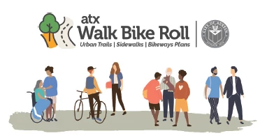
1.3 ATX Walk Bike Roll
ATX Walk Bike Roll was a coordinated effort by the City of Austin to update Austin’s Sidewalk, Urban Trails, and Bicycle Plans. These plans
guide how we build urban trails, sidewalks, pedestrian crossings, and bikeways and where we need them most. Updating these plans together improves coordination to create a
complete active transportation network, bringing us closer to achieving the Austin Strategic Mobility Plan (ASMP) goal of increasing how many people walk, bike, or take transit. The guiding values of the ATX Walk Bike Roll process are shown in the text box on the following page. In particular, ATX Walk Bike Roll centered racial equity throughout the plan update process. Racial equity can be defined as “the condition when race no longer predicts a person’s quality of life outcomes in our community.” The following selection from the ATX Walk Bike Roll Equity Framework highlights the need to focus on racial equity through the three plans: Community influence on active transportation decisions has historically relied on the
proactivity of the public. However, we acknowledge that even when communities who have been historically oppressed have advocated for their neighborhoods, the internal practices and biases within the City structure have ignored the concerns and feedback from these communities. Regional and local advocacy organizations, which may or may not fully reflect Austin’s diversity, were historically the primary or sometimes only stakeholders. In addition, the City prioritized projects requested via services such as 3-1-1 until recently. Practices like these favor neighborhoods with higher capacity for civic involvement. In addition, we acknowledge that since we haven’t fully evaluated the equity of all practices, inequities may continue to be perpetuated in several ways, including: 1) How we prioritize projects, 2) How we engage communities, and 3) How we measure, and therefore evaluate, performance and outcomes.
Previous engagement efforts
The Urban Trails Plan was built upon a strong foundation of community input from previous planning efforts. In particular,
the ASMP included four phases of engagement that actively connected with communities citywide, with specific focus on those that had been previously missing. Critical voices from historically
underrepresented and underserved populations guided the ASMP, including people of color, seniors, youth, and people with disabilities. In a survey performed at the beginning of the ATX Walk Bike Roll engagement process, 55 percent of respondents (61 percent of focus population* respondents) said they had NOT participated in a public process (such as a meeting or survey) where decisions about trails, sidewalks, or bikeways had been made. Therefore, additional input from the community was vital to guide the development of the Urban Trails Plan, building upon previous input related to walking and biking priorities. A summary of the input is provided in a separate document. “I am pleased to see the efforts and progress Austin is making in becoming more bike and pedestrian friendly. However, we have a long way to go.” —Community member comment, Survey, August -
September 2021
*Focus populations are respondents who either reported an annual income below $50,000, or reported a race /ethnicity other than non- Hispanic White.
Guiding Values
ATX Walk Bike Roll is about more than just getting from place to place. Here are a few examples:
Communities – Urban trails, sidewalks, and bikeways are an important part of our local transportation system. Access to different travel options
influences how communities grow, where we choose to live, and how we interact. Equity and Diversity – Austin’s transportation options need to serve
everyone. Your life experience, race/ethnicity, cultural background, or ability should not make it harder for you to get around. Mobility and Accessibility – Walking, biking, and rolling are safe, affordable, and don’t require a license. Because sidewalks, urban trails, and bikeways are available to a broad range of ages and abilities, they help create more opportunities for people to participate in their community. Health and Environment – Our transportation system impacts our physical, social, mental, and environmental health. People will walk, bike, or roll more often when they have safe and easy routes to take. This can help cut down on car traffic and its negative environmental impacts. Connections – Urban trails, sidewalks, and bikeways connect communities to businesses, parks, and neighborhoods. Transportation and Housing Affordability – As Austin grows, so do housing costs and the cost of transportation. ATX Walk Bike Roll can help by providing a low-cost way to travel through a network of sidewalks, bikeways, and urban trails with easy access to transit throughout the city.
1.3.1 Applying the Equity Framework
The Equity Framework offered guidance on how to center equity at each stage of the planning and decision-making process. As part
of this, a concerted effort was made during ATX Walk Bike Roll to ensure that participation in community engagement, “exceeds the racial/ethnic and income demographic makeup of the city and reflects the voices of those most negatively impacted by the process.”1 This effort came short of meeting this goal; however, when reviewing public input results, comments received from the focus population were compared to total responses to review differences and elevate input received from the focus population. In addition, to general online engagement, targeted engagement strategies, such as paid Community Ambassadors and Spanish-language focus groups, were used to reach the focus populations for this effort: Black, Hispanic/Latinx, and other people of color, and those earning less than 80 percent of the median household income. Robust engagement will continue as the Plan is implemented on a
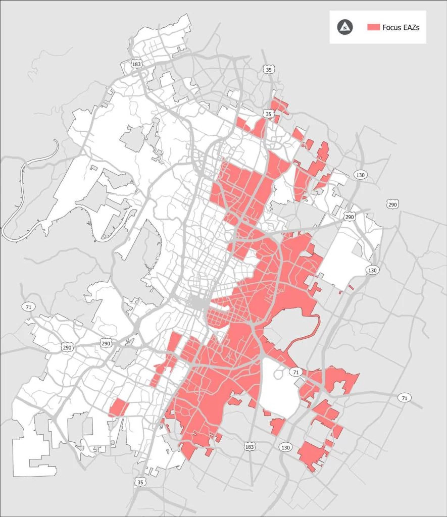
project by project basis. To provide consistency in measuring equitable outcomes across the plans and other City initiatives, the City of Austin, in collaboration with members of the community, developed Equity Analysis Zones to understand which 1 ATX Walk Bike Roll Equity Framework. areas of Austin have higher concentrations of historically marginalized populations. Equity Analysis Zones (EAZ) are based on Census tracts and include nine different US Census American Community Survey (ACS) variables that reflect an area’s social and economic vulnerability. The EAZs are classified into five different categories, from Least Vulnerable to Most Vulnerable. Figure 1-3 shows the majority of the Most Vulnerable and Medium-High Vulnerable Equity Analysis Zones are located on the east side of Austin. Many of these areas were targeted through a historic practice called redlining, where banks and other institutions withheld investment based on the racial/ethnic or economic make-up of the community. Many of these areas are now experiencing high rates of displacement. More information on EAZs and historic inequities in planning and development in Austin can be found in the ATX Walk Bike Roll Equity Framework.
What we heard
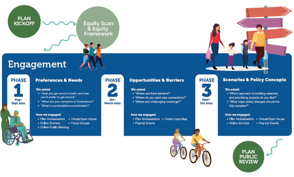
“Ethnic, low-income and minority segments of town are vastly undeveloped and underserved by Austin’s historic transportation plans leaving them without the necessary transportation infrastructure needed to thrive in their communities.”
Engaging with communities and individuals throughout ATX Walk Bike Roll was crucial, especially to understand community priorities and to seek public direction on key policy and investment decisions. Public input, guided by the Equity Framework, steered the planning process at strategic points throughout ATX Walk Bike Roll. Because the scale of this project spanned several planning areas—urban trails, sidewalk improvements, and bikeways—there were multiple phases of community engagement. In each phase, the team focused on tailored questions to receive constructive feedback from the public to shape the updated plans. These green color text boxes throughout this document highlight what we heard through community engagement and how the feedback received is incorporated into the planned urban trail system and implementation strategies. The ATX Walk Bike Roll process prioritized engaging with people of color and people with low incomes. In several locations throughout this document, we refer to “focus populations” as short-hand to refer to this group. More information on the planning process, the Equity Framework, and outcomes of community engagement during the ATX Walk Bike Roll process can be found in Appendix A.
The ATX Walk Bike Roll Equity Framework was applied to this Plan by engaging with, evaluating impacts for, and prioritizing needs of people of color and people with low incomes, who have historically been underserved or negatively impacted by planning and infrastructure decisions.
1.3.2 Equitable Trail Development
A world-class trail system is used and enjoyed by people of all backgrounds, regardless of race, ethnicity, income, or health condition. Urban trails are
essential public infrastructure as they provide opportunities for recreation, improve community health, and offer a low-cost transportation option. However, trails are viewed by some as signals of neighborhood change and displacement. With the cost of living increasing in Austin, some perceive urban trails as an amenity for wealthier newcomers. The ATX Walk Bike Roll Equity Framework and multiple rounds of public engagement took this perception into account while listening to community members and putting forth recommendations for implementing a more equitable trail system. The City of Austin is committed to creating a trail system that is accessible and welcoming to all people, regardless of race, ethnicity, income level, or social background. Chapter 3 discusses this topic in more depth.
What we heard
Throughout the ATX Walk Bike Roll process, concerns about affordability and displacement were shared—especially by people of color and people
with low incomes. Policies to address these issues and keep transportation affordable are essential to peoples’ ability to happily live and thrive in the city. In the words of one community member, people are “concerned that urban trails and sidewalk improvements are benefiting wealthy white residents... that people of color and low-income residents are being pushed
out, and that people of color will not be around in 5-10 years from now, after additional improvements to sidewalks, bike lanes, and urban trails.” The importance of place-based equity is highlighted by this participant’s quote: “This all seems great, but don’t forget about the existence of North East Austin in your plans. The availability of transit, safe walking routes, and urban trails is non-existent north of Rundberg.”
1.4 Goals and Action Items
The ASMP policies create a framework for this Plan’s urban trail goals. These goals were developed as part of the 2014 planning process and continue to be relevant areas of focus. In addition to these original goals, some new or modified goals emerged as part of community engagement for ATX Walk Bike Roll, shown in italics below.
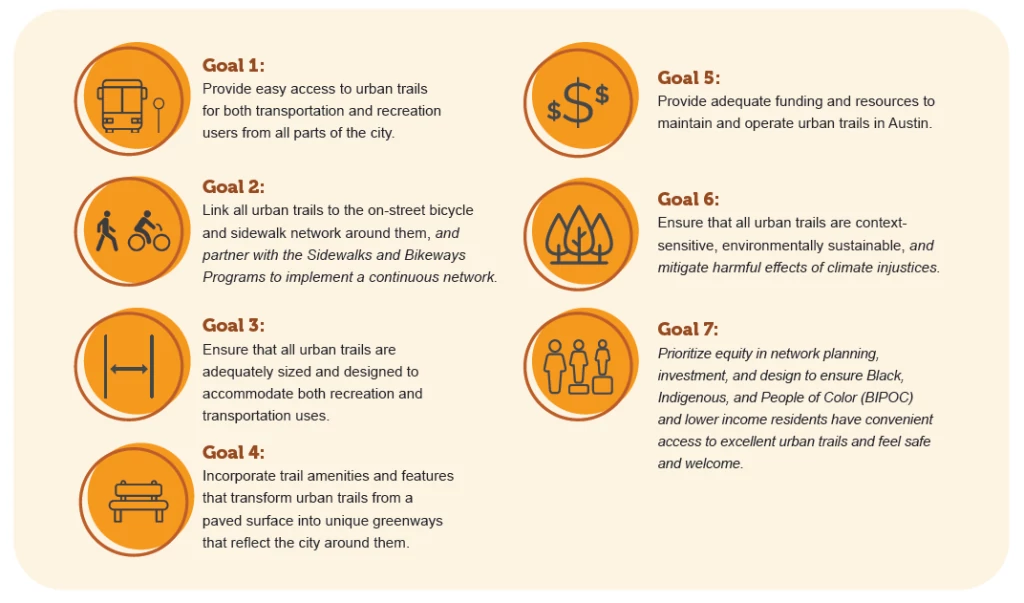
1.4.1 Action Items
The City has established clear action items and targets to measure progress toward this Plan’s goals. Some of these action items originate from the Austin Strategic Mobility Plan and will be marked with an asterisk (*). The others have been identified as part of the ATX Walk Bike Roll planning process. More context for each can be found throughout the Plan.
1.5 Key Issues and Opportunities
Key issues and opportunities for Austin’s urban trails system were identified through community engagement, interviews with City staff and partner agencies, field work, and observations by the consultant team. These findings informed the network prioritization methodology, trail design guidance, and recommended strategies in this Plan. Each topic area presented below is connected to the corresponding chapter in this Plan, which discusses the opportunities more in depth and provides recommendations.
- Connectivity: Chapter 2 Network Updates and Prioritization
- User Safety & Comfort: Chapter 3 Implementation Plan
- Equity: Chapter 3 Implementation Plan
- Trail Alignment and Construction: Chapter 3 Implementation Plan
- Partnerships & Coordination: Chapter 4 Managing and Maintaining a World Class Network
- Maintenance: Chapter 4 Managing and Maintaining a World Class Network.
2: Network Updates and Prioritization
This chapter summarizes the process of updating the urban trail system from the 2014 Urban Trails Plan and sorting proposed projects into tiers based on priority for implementation. The process involved the following three steps, each of which was guided by input from the community, stakeholders, Community Ambassadors, and City staff:
1. Update the Proposed Urban Trail Network
2. Develop and compare three different network Build-Out Scenarios
3. Use community and City staff input on the Build-Out Scenarios to identify the 20-year Urban Trail Network Priorities: a subset of projects from the Proposed Urban Trail Network that will be prioritized for implementation.
Issues and Opportunities to Improve Connectivity
- Issues:
- The existing urban trail network is not continuous because of gaps in the urban trail, bicycle, and sidewalk networks.
- Railroads, highways, major streets, creeks and water-bodies, and disconnected street networks can be barriers for pedestrians and people on bikes. People often must walk or bike long distances to reach a designated crossing.
- Due to rising housing costs, more residents are moving to the outer limits of the city where transportation options are lacking.
- Sprawling development patterns necessitate longer trips which are challenging without a car due to infrequent transit, disconnected street networks, and lack of sidewalks, bicycle facilities and trails that connect to transit stops.
- The existing urban trail network is not continuous because of gaps in the urban trail, bicycle, and sidewalk networks.
- Opportunity:
- Private developers may be able to build out portions of the urban trail network as sites are developed or redeveloped
- Partner with agencies completing large-scale infrastructure projects such as Capital Metro, TxDOT, CTRMA, and neighboring cities and counties.
- CapMetro’s MetroBike expansion may offer improved connections to transit
- Prioritize and implement projects that overcome major barriers
2.1 Existing Network Overview
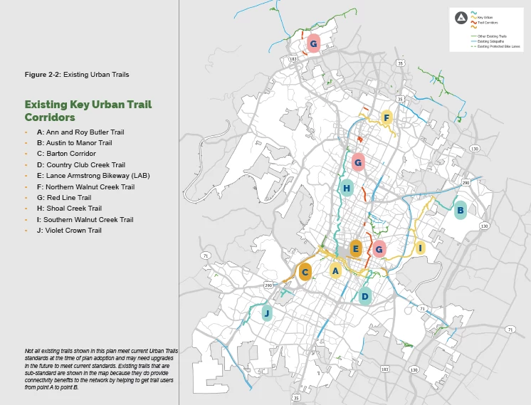
Since the 2014 plan, the City of Austin has constructed 37 miles of new urban trails, bringing the total existing network up to about 68 miles. Some recently completed urban trails include: the Lower Boggy Creek Trail (2021), Upper Boggy Creek Trail (2019), and the Northern Walnut Creek Trail (2015, expanded in 2019 and 2021). See Figure 2-2 for a map of the existing trail network, identified from the 2014 Urban Trails Plan. As it stands today, the current urban trail system is within proximity to:
- 355,104 people (living within ½ mile), which is about 37 percent of the city’s population
- 47 schools (within ¼ mile)
- 559 transit stops (bus stops and light rail stops) (within ¼ mile)
- 181 parks (within ½ mile)
Additionally, the current urban trail system crosses 88 barriers (highways, railroads, creeks/rivers) and 39 percent of existing urban trails are located in Most Vulnerable or Medium High Vulnerable EAZs (which make up 29 percent of the city’s land area).
2.2 Updates to the Proposed Network
The 2014 Urban Trails Plan recommended a 407-mile network. Since 2014, 37 miles of that network have been constructed. As part of this update, several changes, additions, and modifications were made to the proposed network. Changes include:
- Modifications to the network based on fieldwork, which found some segments to be infeasible while identifying alternative, more feasible alignments in some locations (Appendix B)
- Addition and modification of segments by City staff
- Removal of redundant segments
- Addition of segments submitted by community members through the Online Input Map during Spring 2022 that address key concerns, such as segments that will:
- Be located in a neighborhood with few existing or planned trails or parks;
- Cross a network barrier, such as a highway or railroad;
- Be located in the Most Vulnerable or Medium-High Vulnerable Equity Analysis Zones;
- Fill short gaps in the existing urban trail system; or
- Provide short connections between street segments (e.g., cul-de-sac connectors).
What we heard
“Improve connections to eliminate ‘dead end’ routes.”
“Have continuous paths/routes. Often times there are ‘improved’ streets/ routes that have missing gaps between. Rendering them useless or dangerous.’
—Community member comment, Survey, August - September 2021
Urban Trails and Sidepaths
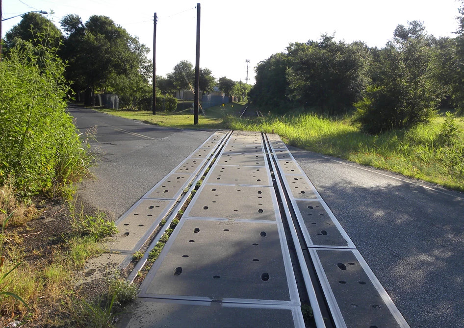
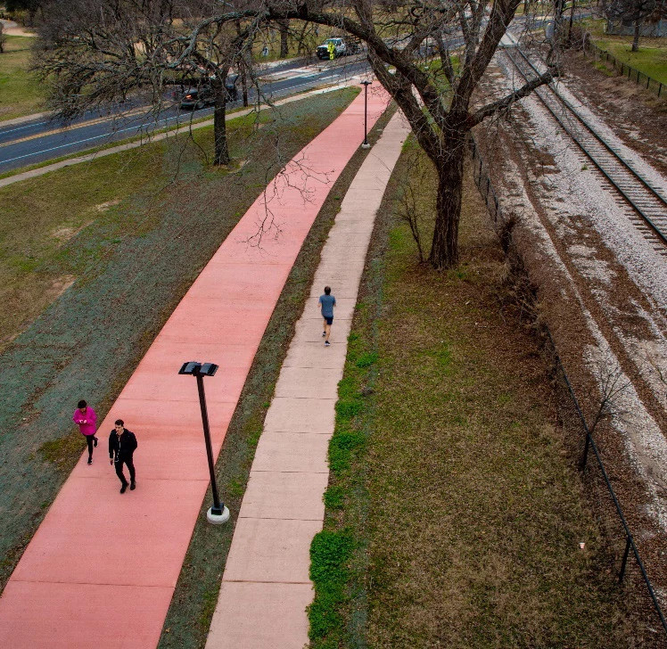
The Texas Department of Transportation (TxDOT) is required by law to accommodate pedestrians and bicyclists on all state and federally funded projects. The goal of this policy is to help create healthier communities, reduce air pollution, decrease congested roadways and promote more livable, safe and cost-efficient communities. Historically, a common practice for accommodating bicyclists along major TxDOT roadways included construction of a wide curb lane for shared automobile and bicycle use. Fortunately, more recently, TxDOT has begun constructing shared use paths as a standard part of projects. However, there is still room for improvement as often these paths, known as sidepaths, are directly adjacent to high-speed car traffic and are not always built to urban trail standard widths. The Urban Trails Plan endorses the construction of off-street, shared use paths to safely and conveniently accommodate bicyclists and pedestrians. The standards of these shared use paths should reflect the urban trail standards defined in this plan. As shared use paths along highways are anticipated to be constructed by TxDOT (or Central Texas Regional Mobility Authority), they have not been included in the prioritization for the Urban Trail Program. However, shared use paths along highways are a key part of our active transportation network and the Urban Trails Program should work with TxDOT to promote the construction of shared use paths along highways.
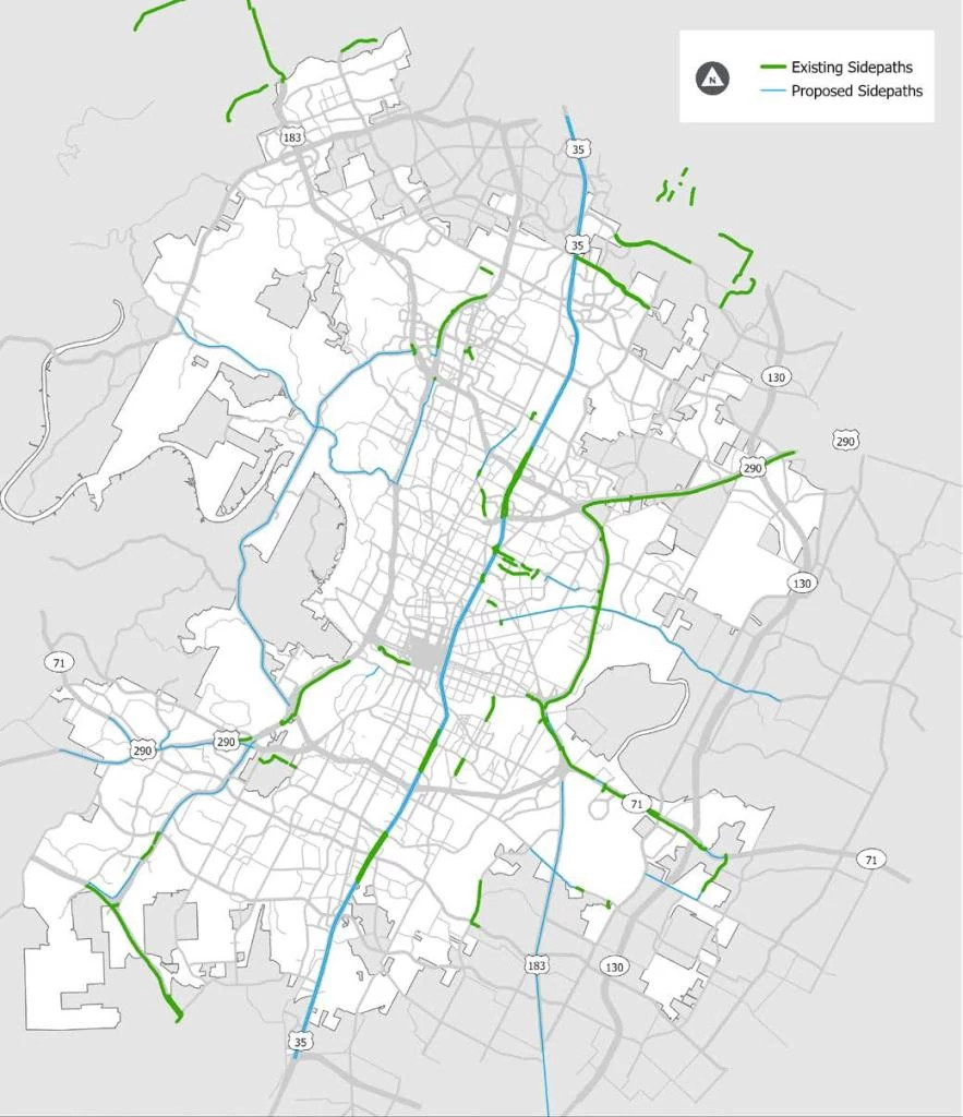
Federal agencies and TxDOT use the term shared use path to describe multi-use paths designed primarily for use by bicyclists and pedestrians for transportation and recreation purposes. In Austin, we call shared use paths within an independent right-of-way (e.g., utility corridors, parks, or natural areas such as along a creek) an urban trail, and shared use paths adjacent to a roadway a sidepath. The term sidepath is used in best practice guidance by national organizations (American Association of Highway and Transportation Officials or AASHTO and National Association of City Transportation Officials or NACTO).
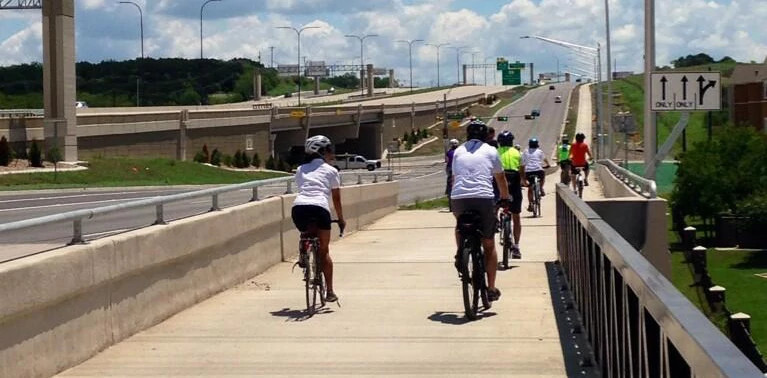
A group of people bicycling on a shared use path along US 290. Credit: CTRMA
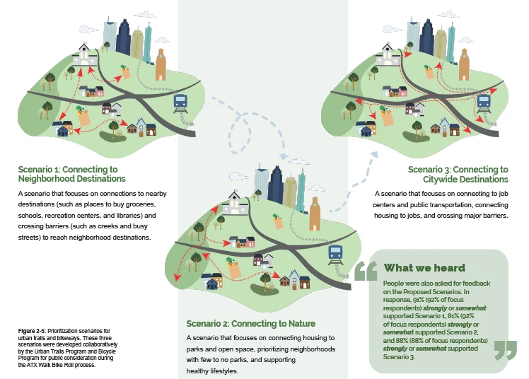
2.3 Build-out Scenarios
The City aspires to build the entire Proposed Urban Trail Network. However, the City of Austin has limited resources and must decide which projects to fund first. To do so, a method for
prioritizing projects was created. This new method of prioritizing projects centers on a data-driven process strongly influenced by policies from the Austin Strategic Mobility Plan and the ATX Walk Bike Roll Equity Framework. Three conceptual scenarios were developed based on the different priorities identified by public feedback and the ATX Walk Bike Roll
Community Ambassadors, presented on the next page (Figure 2-5). Each scenario illustrated a different way of prioritizing which pieces of the Proposed Urban Trail Network are constructed first. These scenarios were presented to the public to gather input on what order urban trail projects are built. For more information on the details of each scenario, see Appendix C: Urban Trail Network Maps, Scenarios, and Prioritization.
What we heard
Public engagement in fall 2022 asked Austinites to help determine how urban trails are prioritized. People were asked to rate the importance of variables used in the prioritization scenarios, including:
- Improved access to parks and open spaces
- Improved access to job centers and citywide destinations, such as downtown and universities
- Improved access to local, nearby destinations, such as corner stores and schools
- Improved connections across major barriers such as highways, railroads, and creeks
- Fills gaps in the urban trail system
- Improved access to transit
In the prioritization variable ranking question, all variables were generally ranked evenly with “improved connections across major barriers such as highways, railroads, and creeks” being ranked slightly higher than the others for both the general and focus populations. Both groups also ranked “improved access to local, nearby destinations, such as corner stores and schools” as the second highest ranked choice.
For the third variable, the general population ranked “improved access to job centers and citywide destinations” as third, while the focus population ranked “Improved access to parks and open spaces” as third instead.
2.4 Network Priorities
After extensive community engagement and review of the three conceptual scenarios, additional factors based on City policies were folded into a data-driven prioritization model. While the 2014 Urban Trails Plan identified 47 miles of Tier 1 trails, most of those have been built or are under design and construction. This new prioritization model was used to identify the next set of top priority urban trails projects. In short, this prioritization model answers the questions: What do we build next? Are decisions about what to build next equitable? Each urban trail project is assigned a score between zero and 100 points. Figure 2-6 shows the variables used for prioritization and the weight of each (expressed as the percentage of the maximum 100 points).
(Data driven iconography)
Feasibility and Qualitative Factors
A computer generated approach is only part of how projects get prioritized. Staff judgment and an understanding of feasibility (how easy or hard
a trail is to construct) is also needed to prioritize projects that best meet the goals identified during community outreach. The qualitative factors that were used to adjust final prioritization scores for proposed projects include:
- Feasibility
- Coordination with Other Infrastructure Projects
- Completion of Key Corridors (See section 2.5)
- Existing Preliminary Engineering and/or Design
A Tiered Approach
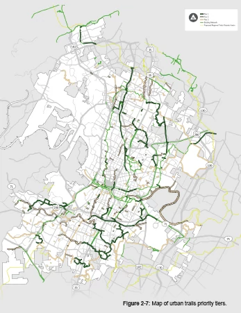
The breakdown of tiers is as follows:
- Tier 1: Approximately 94 miles of trails
- Tier 2: Approximately 78 miles of trails
- Tier 3: Approximately 96 miles of trails
For more information on how the projects were tiered, see Appendix C: Urban Trail Network Maps, Scenarios, and Prioritization.1
2.5 Key Urban Trail Corridors
While all urban trails provide benefit to the community, a key part of the urban trail system are the main “spine” corridors. These are long urban trail corridors that provide connectivity across the city. Some users may travel the length of the corridor, while the average user may travel only a small piece of it to reach a nearby destination. To better understand the Proposed Urban Trail Network, this section includes a brief description of key urban trail corridors, both existing and proposed. These trails are located in different areas of the city and while all important to the urban trail system, a key trail corridor defined here should not be implemented to the detriment of trails in areas that have been historically under invested in or under-served. More information about active urban trail projects and the existing urban trail corridors can be found at: AustinTexas.gov/UrbanTrails
Ann and Roy Butler Trail
- Location: Loop trail around Lady Bird Lake from Mopac Expressway to North Pleasant Valley Road
- Length: 10 miles
- Status: Existing
- Key Features: The Ann and Roy Butler Trail provides a continuous loop trail around Lady Bird Lake. The surface of the trail varies; most is decomposed granite, with portions of concrete trail, and a concrete boardwalk along the southeast segment. The trail currently connects to six bridges with dedicated pedestrian and bicycle facilities allowing trail users to cross the lake to reach their destination.
Austin to Manor Trail
- Location: From Daffan Lane to Ben E. Fisher Park
- Length: Proposed 5.5 miles
- Status: Partially Complete
- Key Features: Austin to Manor Trail currently connects to the Southern Walnut Creek Trail at Daffan Lane and travels within Walter E. Long Metropolitan Park through the Decker Tallgrass Prairie Preserve ending after 2.5 miles at a turnaround near Lindell Lane. The second and final phase, under construction as of Spring 2023, will provide a connection from Lindell Lane to Ben E. Fisher Park in Manor. This trail follows CapMetro’s future Green Line rail and will provide connections to future transit stations.
Barton Corridor
- Location: From Y at Oak Hill to Barton Creek
- Length: Proposed 10 miles
- Status: Partially Complete
- Key Features: The Barton Corridor consists of the Stratford to Barton Springs Connector, the Mopac Bicycle and Pedestrian Bridge, TxDOT’s Oak Hill Parkway Project, and the YBC Trail. The corridor, when complete, will connect much of the Oak Hill and Barton Creek areas of Austin to Downtown Austin.
Bergstrom Spur
- Location: From Vinson Drive to East Riverside Drive near US 183
- Length: Proposed 6.5 miles
- Status: In Design
- Key Features: Austin’s first substantial rails-to-trails project, the Bergstrom Spur is located in an abandoned rail corridor. The trail is designed as a dual track trail with separate paths for pedestrians and people on bikes. The trail will provide direct connections to St. Elmo Elementary School, multiple transit stops, north-south protected bike lanes, and other nearby destinations as well as a safer crossing of IH-35.
Country Club Creek Trail
- Location: From Roy G. Guerrero Metropolitan Park to Mabel Davis District Park and Bergstrom Spur Trail
- Length: Proposed 3.5 miles
- Status: Partially Complete
- Key Features: The Country Club Creek Trail serves as an important route in Southeast Austin. It begins at Ann and Roy Butler Trail, and runs through Roy G. Guerrero Metropolitan Park as a decomposed granite trail. The trail extends south to Mabel Davis District Park as a mix of on-street facilities separated from cars and a concrete trail. A project to close a remaining gap of Country Club Creek Trail from East Riverside Drive to East Oltorf Street is currently in design. A further extension of the trail from Ventura Drive to Bergstrom Spur Trail south of E. Ben White Boulevard is planned.
Lance Armstrong Bikeway (LAB)
- Location: From Mopac Expressway to Montopolis Drive
- Length: 6 miles
- Status: Existing, small gaps remain
- Key Features: The LAB provides an east-west route across central Austin, linking to transit stations and crossing IH-35. Some sections of the LAB are urban trail, while other sections are on-street bike facilities (e.g., bike lanes, protected bike lanes, neighborhood bikeway) and sidewalks. At the Downtown Station, the alignment begins to follow CapMetro’s MetroRail Red Line eastbound. Gaps in the trail still exist between Onion Street and Comal Street and Chicon Street to San Saba Street.
Little Walnut Creek Trail
- Location: West Rundberg Lane to US 290 and Manor Road to East 51st Street
- Length: Proposed 7.5 miles
- Status: Proposed
- Key Features: The Little Walnut Creek Trail would provide access to nature in North Austin. Located in a densely developed area, the trail would connect neighborhoods, multi-family apartment complexes, commercial destinations and parks. The trail would also include a grade-separated crossing of IH-35, providing east-west connectivity across the highway.
Northern Walnut Creek Trail
- Location: From Balcones District Park to Southern Walnut Creek Trail
- Length: Proposed 13 miles
- Status: Partially Complete
- Key Features: The existing Northern Walnut Creek Trail is a 10-12 ft wide concrete trail that extends 4.4 miles from Balcones District Park to Walnut Creek Metropolitan Park and west to Cedarbrook Drive. Eventually, the trail will connect to Southern Walnut Creek Trail creating a unified trail system. Within Walnut Creek Metropolitan Park, the Northern Walnut Creek Trail intersects with a 10+ mile network of natural surface trails used by many for hiking, mountain biking, accessing the creek, and more.
Onion Creek - South Boggy Creek Trail
- Location: From West Gate Blvd to the confluence of the Colorado River
- Length: Proposed 18 miles
- Status: Proposed
- Key Features: The Onion Creek - South Boggy Creek Trail system would provide east-west connectivity across South Austin. The trail would connect neighborhoods to parks and provide a grade separated crossing of IH-35. To the east, the trail system leaves the city limits and will be implemented by Travis County as part of a regional trail network.
Red Line Trail
- Location: Downtown Austin to Leander along CapMetro’s Red Line Rail
- Length: Proposed 32 miles (not all within City of Austin Limits)
- Status: Partially Complete
- Key Features: Red Line Trail presents a great opportunity for north-south connectivity starting from Central East Austin and spanning the length of the city. It provides key connections to public transit, including CapMetro’s MetroRail Red Line. The largest continuous portion of Red Line Trail completed and open to the public extends from Pedernales Street at Canterbury Street to 34th Street and Cherrywood Road. Additional smaller segments have been completed as well and more are under design.
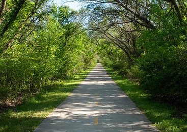
Shoal Creek Trail
- Location: From Ann and Roy Butler Trail at Lady Bird Lake to US 183
- Length: 9.5 miles
- Status: Existing, but in many locations does not meet urban trail standards.
- Key Features: Shoal Creek Trail is one of the oldest trail systems in the City of Austin. It provides key north-south connectivity through Central Austin. North of 38th Street, an on-street protected bikeway and sidewalk, serves as the trail alignment.
Southern Walnut Creek Trail
- Location: From Govalle Park to Johnny Morris Road/Daffan Lane
- Length: 8.7 miles
- Status: Existing
- Key Features: The Southern Walnut Creek Trail is a 10 ft wide concrete trail, primarily located within parks or undeveloped green space. It connects to multiple neighborhoods and landmarks including Govalle Park, Mokan Trail, the YMCA at Hwy 183, Davis White Northeast Neighborhood Park, Walnut Creek Greenbelt, the Austin Tennis Center and the Austin to Manor Trail.
Violet Crown Trail
- Location: From Ann and Roy Butler Trail at Lady Bird Lake to US 183
- Length: 9.5 miles
- Status: Existing, but in many locations does not meet urban trail standards.
- Key Features: Shoal Creek Trail is one of the oldest trail systems in the City of Austin. It provides key north-south connectivity through Central Austin. North of 38th Street, an on-street protected bikeway and sidewalk, serves as the trail alignment.
Williamson Creek Trail
- Location: From Sunset Valley to McKinney Falls State Park
- Length: 8 miles
- Status: Proposed
- Key Features: Located primarily within an existing east-west greenbelt, Williamson Creek Trail would extend across South Austin. The trail will connect neighborhoods, provide access to parks and green space, including McKinney Falls State Park, and other nearby destinations. To the east, the trail could connect to the proposed Onion Creek Trail System.
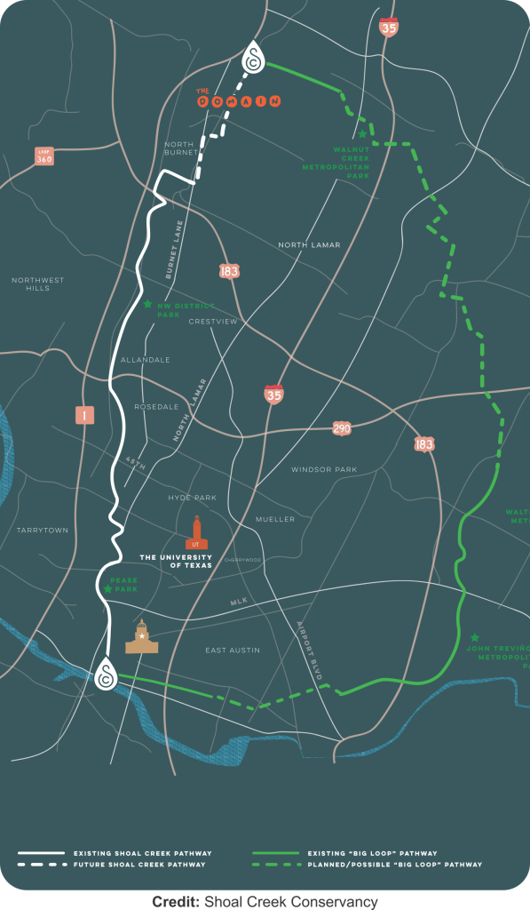
"The Big Loop"
The Big Loop Trail is the vision for a 30-mile loop of urban trails that will traverse Austin by way of creeks and parks. The Big Loop is comprised of multiple existing and proposed urban trail segments including: Shoal Creek Trail, Red Line Trail, Northern Walnut Creek Trail, Southern Walnut Creek Trail, Mokan Trail and Lance Armstrong Bikeway, with a few remaining gaps to be completed through on street all ages and abilities infrastructure. This 30-mile loop will serve a broad number of users, connecting them to parks and open space as well as to home, school, work and other daily destinations via protected pathways, both alongside existing roadways and within parkland. When complete, the Loop will not only serve a recreational function, but a significant regional transportation one as well.
3: Implementation Plan
Together with identifying a well-connected and safer urban trail system, this Plan provides guidelines for equitable network implementation. While the guidelines presented in this Chapter do not address every aspect of implementation, they are responsive to specific needs identified by the people who build trails and those who use them. Recognizing the City of Austin has a successful and growing Urban Trails Program already established, these strategies are tailored to equitably advance the urban trail system beyond current practices in accordance with the ASMP policies.
Addressing Equity
Issues:
- Concerns about displacement of residents and businesses as Austin faces a citywide affordability crisis.
- Existing walking and biking infrastructure in Austin is disproportionately located in wealthier areas, and a more equitable approach to investment is needed.
- Difficulties walking or biking outside in the heat for long periods, especially as temperatures rise due to climate change. Lack of shade and publicly accessible water fountains compound this issue.
- Traditional forms of public outreach, such as public meetings, don’t widely reach historically underserved communities.
Opportunity
- Potential to collaborate and/or partner with City of Austin departments or community organizations on existing anti-displacement efforts.
- An expanded community ambassador program, building on the success of the ATXWBR ambassadors could conduct outreach and educate the public on specific trail projects.
- Placemaking, such as community art or educational signage, can educate trail users on the history of an area and celebrate the unique culture of a community.
- Adding tree planting on urban trail projects can begin to increase overall tree canopy.
3.1 Equity and Affordability
The City is committed to an equitable approach to building the urban trail system. This requires asking ourselves, “Who benefits from the trail? Are we building trails in neighborhoods that need them most? Do people in low-income communities and communities of color feel welcome and comfortable using trails? Do we regularly listen to and learn from people from different backgrounds and circumstances as we plan and implement trail projects?” The content within this section provides structure and resources to address those questions.
In addition, the Equity Process Flowchart included within the ATX Walk Bike Roll Equity Framework should be used as a guide for centering equity at each stage of the decision making process.
3.1.1 Mitigating Displacement
Rising housing costs in Austin are making many neighborhoods unaffordable. Some residents express concerns that the addition of trails in a neighborhood can further decrease affordability leading to displacement. There is limited data on this topic nationwide, with most studies focused on high profile, transformative projects such as the Highline in New York City or the Beltline in Atlanta. Due to this, it is recommended the City of Austin conduct a study of displacement impacts near trails.
In some instances, the neighborhood is already vulnerable to displacement due to both demographic characteristics and market pressures, unrelated to the development of a new trail. The City of Austin’s Displacement Risk Index classifies census tracts within the City of Austin into four categories of displacement risk:
- Active: vulnerable populations present, active demographic change, accelerating or appreciating housing market
- Vulnerable: vulnerable populations present, no significant demographic change, some tracts are near or contain high-value and high-appreciating areas
- Chronic: vulnerable populations have been displaced, significant demographic change has occurred, the housing market is high-value and appreciated
- Historic exclusion: these areas have historically excluded vulnerable populations and are not subject to gentrification and displacement in the same ways
When starting a new trail project, the Urban Trails Program should determine if the trail is located in an area identified as “active” or “vulnerable.” When planning a trail in these areas:
- Urban Trails staff should seek to partner with the Housing and Planning Department or other agencies to build on anti-displacement work already underway. Currently, anti-displacement and affordable housing funds are limited and active transportation bond funds that support trail development cannot be spent on non-trail costs. Due to this, more work is needed to understand how a meaningful partnership can be achieved. A recent example of mobility investment paired with displacement prevention is Council’s decision to include $300 million in anti-displacement funds as part of the overall Project Connect tax rate election where voters approved the transit system.
- Project outreach events should include information and/or education about existing stabilization efforts such as home repair programs, tenant protections, emergency rental assistance opportunities and others as available and appropriate for the community.
Additionally, the City should look for opportunities to add permanently affordable housing near trail projects. This can be achieved through private development, for instance by making it a requirement in planned unit developments (PUDs) near urban trails or through development of city-owned property along or nearby existing or future urban trails.
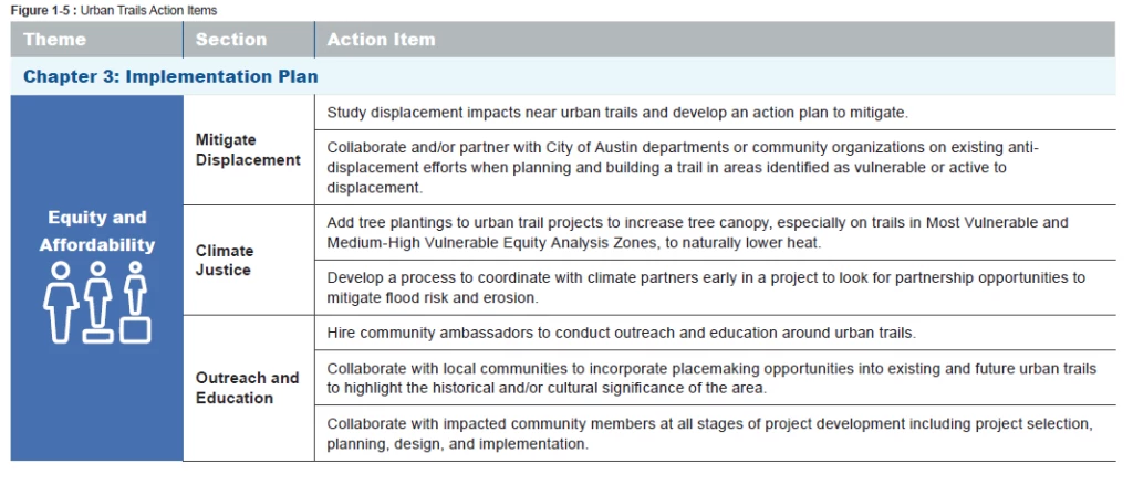
Action Items
Study displacement impacts near urban trails and develop an action plan to mitigate.
Collaborate and/or partner with City of Austin departments or community organizations on existing anti-displacement efforts when planning and building a trail in areas identified as vulnerable or active to displacement.
What we heard
“[A man I spoke to] was a native Austinite who had attended Allison Elementary and returned to be a crossing guard. He still lives in the neighborhood but he understands that his time in the community is limited due to impending displacement”
- ATX Walk Bike Roll Community Ambassador Field Notes
3.1.2 Climate Justice
As noted in the Austin Climate Equity Plan, climate change affects everyone, and the impacts are not felt equally among all communities. Due to systemic racism, Black, Indigenous, and People of Color (BIPOC) are particularly vulnerable as climate-harming activities have historically been delegated to communities of color. Among other impacts from climate change, the BIPOC community faces increased exposure to heat related illnesses, respiratory illnesses, and vector-borne diseases, as well as displacement and reduced mobility due to flooding, extreme weather, and extreme heat related impacts.
In Austin, urban trails can begin to address heat and flooding impacts, by increasing tree planting and by identifying opportunities to partner with the City’s Watershed Protection Department and/or other climate partners to mitigate flood risk in communities of color.
What we heard
“Heat island effect is a real barrier, especially as climate change ramps up. Shade is critical in addition to the actual safety of pedestrians and bike[rs], etc. Include in plans tree plantings wherever possible along any sidewalk, trail, and bus stop.”
- Community member comment, Survey, October 2021
Shade
A recent study from researchers at the University of Texas in Austin looked at the connection between temperatures and trail use data along the popular Ann and Roy Butler Hike and Bike Trail. The study found that pedestrian use declined when temperatures rose above 81 degrees Fahrenheit and bicycle use decreased above 91 degrees. Simply put, the hotter it gets, the less people want to be active outside. With summers getting hotter on average and with more days of over 100 degrees Fahrenheit each year in Austin, trees are essential parts of active transportation infrastructure that are necessary to provide cooler temperatures which are conducive to walking and bicycling.
While the study focused on the Ann and Roy Butler Hike and Bike Trail, it is primarily used for recreation, meaning that in hot weather, users can choose not to use the trail. In many communities, this choice is not available as trail users are dependent on trails to get to work or other key destinations. Due to this reliance on the trail system, it is crucial that tree planting and shade be provided along all active transportation infrastructure throughout the city, including urban trails.
For more details on tree plantings and urban trails, see Appendix D: Urban Trails Design Guide.
Action Items
Add tree plantings to urban trail projects to increase tree canopy, especially on trails in Most Vulnerable and Medium-High Vulnerable Equity Analysis Zones, to naturally lower heat.
Flooding and Erosion
Development patterns, aging infrastructure, and insufficient drainage have increased flood risk in low-income communities and communities of color. Many low-income communities were developed within floodplains to take advantage of lower property values. Climate change and added development continue to increase the severity of floods in these areas.
Many trails are built within creek corridors that are prone to flooding during extreme weather events. An active project along a creek corridor could be an opportunity for the Urban Trails Program to partner with the Watershed Protection Department to stabilize the creek during construction of the trail.
A recent example of this is along Country Club Creek in Southeast Austin. The Urban Trails Program proposed to build a trail along the creek and found that, due to the highly erosive nature of the creek, the trail would need to be built on an elevated boardwalk. Instead of taking this approach, Urban Trails Program staff partnered with Watershed Protection Department staff to develop a joint project that will stabilize the creek, allowing for standard trail construction and preventing further erosion adjacent to an apartment complex.
It is recommended that coordination with Watershed Protection Department and other climate partners (e.g., Office of Sustainability, Austin Resource Recovery Brownfields Remediation, etc.) occur early in the planning process to identify similar partnership opportunities on future projects, especially if the project is located within a low-income community or community of color that is prone to flooding.
Action Items
Develop a process to coordinate with climate partners early in a project to look for partnership opportunities to mitigate flood risk and erosion.
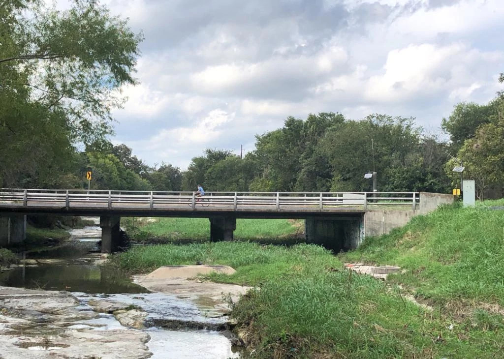
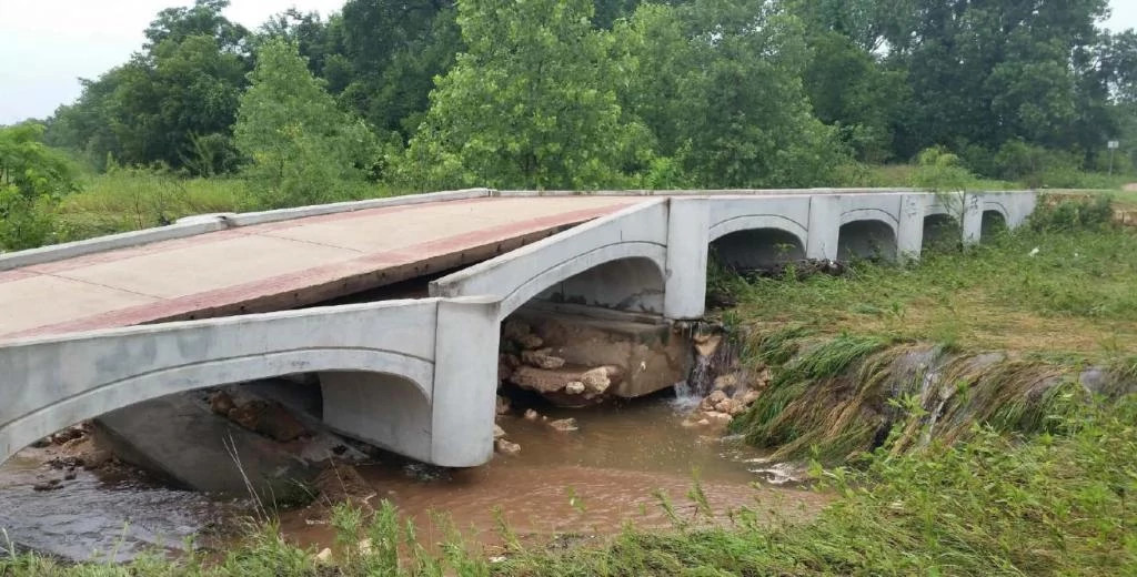
Figure 3-1: Severe flooding in 2015 damaged and later destroyed a trail bridge in Roy G. Guerrero Park. Replacing the bridge was delayed for several years due to ongoing erosion challenges. Credit: Austin Parks And Recreation Department
3.1.3 Outreach and Education
To implement an equitable trail system, the system needs to be planned, designed, and managed in collaboration with low-income communities and communities of color. Low-income communities and communities of color most likely to be impacted by a project should participate in project selection, planning, design, and implementation through collaboration and empowerment.
Currently, the Urban Trails Program conducts public outreach throughout the preliminary engineering and design phases of a trail project. Through current outreach, residents are informed and consulted. Resources are needed to expand this outreach beyond inform and consult to fully collaborate with residents and to do so at more stages of trail implementation, such as project selection.
Community ambassadors were instrumental in conducting outreach as part of ATX Walk Bike Roll and an expanded community ambassador program, building on the success of the ATXWBR ambassadors should be established. Ambassadors could collaborate with city staff, conduct outreach within their communities, and educate the public on specific trail projects.
To bring new and diverse users to existing trails, community ambassadors can work with city staff to hold community events along current trail corridors. These events can increase awareness of the existing trail system and help make them more welcoming to a wider array of Austinites.
Placemaking, such as community art or educational signage, can also be a way to celebrate local communities and educate trail users on the history of the area. Additionally, placemaking along existing or new urban trails can offer an opportunity to hire local artists that represent the surrounding community. More information on placemaking and other design considerations can be found in Appendix D: Urban Trail Design Guide.
Action Items
Hire community ambassadors to conduct outreach and education around urban trails.
Collaborate with local communities to incorporate placemaking opportunities into existing and future urban trails to highlight the historical and/or cultural significance of the area.
Collaborate with impacted community members at all stages of project development including project selection, planning, design, and implementation.
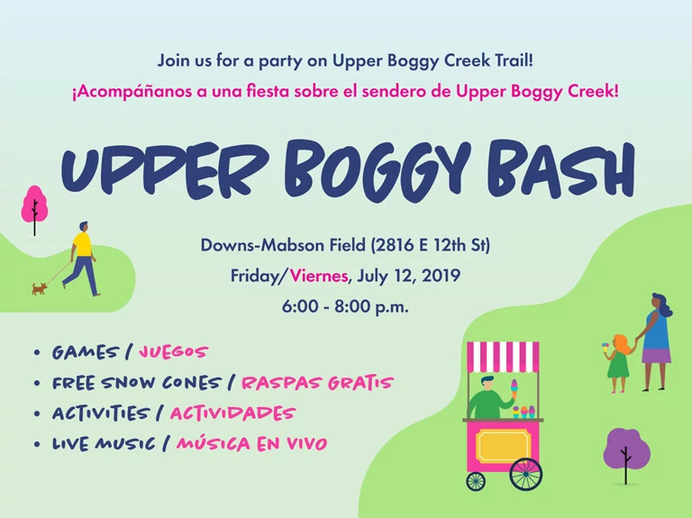
The “Upper Boggy Bash”
Upper Boggy Bash celebrated the completion of Upper Boggy Creek Trail (a portion of Red Line Trail) in East Austin. When Upper Boggy Creek Trail opened in 2019, rather than a traditional ribbon cutting event, the City of Austin held the “Upper Boggy Bash,” a celebration for the community. The Urban Trails Program hired a brass band to lead community members down the trail, community partners were invited to table and provide activities and information along the trail, and free snow cones were offered to attendees.
The goal of this event was to bring more community members to the trail. It was focused on gathering rather than walking or riding bikes to be more inclusive and make sure everyone felt welcome. This kind of community-oriented, temporary programming has the potential to bring more people out on the trail and in doing so improve the community’s comfort in using the trail in the future.
3.2 Design Guidance
Trail designs that deliver a safe, comfortable, seamless, and welcoming user experience are integral to building a world-class trail system. The Urban Trails Design Guide, located in Appendix D, is based on national standards and best practices as applied to the unique conditions that occur in Austin. The Design Guide also incorporates equity considerations based on comments and concerns identified through the Community Ambassadors and public outreach surveys conducted during ATX Walk Bike Roll. The Design Guide includes guidance on trail width based on existing and expected capacity.
Designing and Constructing Trails
Issues:
- Environmentally sensitive areas and regulations, particularly for proposed trails along creek corridors, in flood plains or near Critical Environmental Features.
- Constrained space for trails due to existing structures, railroads, and topographical features.
- Lack of parkland in some areas of Austin that make it more difficult to build urban trails in natural corridors and provide access to nature.
Opportunity
- Create more places for people to connect with nature within the city by constructing trails through natural areas like creek corridors, as well as by bringing shade trees and landscaping to trail corridors in more urban conditions.
- The parkland dedication ordinance requires developers to either dedicate land for new parks and trails or pay fee-in-lieu parkland dedication fees.
- Examine utility corridors that potentially have less of an environmental impact.
3.2.1 Setting the Standard for Quality Trail Design
The Urban Trails Design Guide (Appendix D) supports the goal of providing a distinct, safe, and comfortable urban trail system that works in conjunction with on-street walking and bicycling networks. It serves as a supplemental technical resource that covers topics such as trail width, design speeds, and cross slopes, that can be used in the development of trail specifications, final designs, and construction documents. It includes guidance on shade, lighting, seating, and water fountains all of which are needed for a trail to serve as a true all ages and abilities facility. Planners and designers will also find practical guidance for developing essential features of a trail that make it a sought-out destination. The guidance offers recommendations related to placemaking, wayfinding, and trailheads.
One of the key questions addressed in the Urban Trails Design Guide is how to accommodate current and future trail users into trail design. Specifically: how wide should each trail be?
The Urban Trails Design Guide was developed to give trail planning, design, and construction practitioners resources and tools to develop high-quality trails. The document should also be used in development review, and project inspection to ensure that appropriate, high-quality designs are constructed.
The document will need to evolve over time, as some questions remain to be explored as new and emerging technologies are developed and introduced to Austin’s transportation networks. Specifically, it will be important to apply the latest city, state, and federal design guidance related to automated vehicles, micromobility, and other future technologies in the design of urban trails as it is available.
Action Items
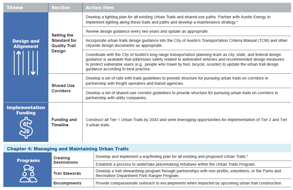
Develop a lighting plan for all existing Urban Trails and shared use paths. Partner with Austin Energy to implement lighting along these trails and paths and develop a maintenance strategy.
Review design guidance every two years and update as appropriate.
Incorporate urban trails design guidance into the City of Austin’s Transportation Criteria Manual (TCM) and other citywide design documents as appropriate.
Coordinate with the City of Austin’s long range transportation planning team as city, state, and federal design guidance is available that addresses safety related to automated vehicles and recommended design measures to protect vulnerable users (e.g,. people who travel by foot, bicycle, scooter) to update the urban trail design guidance according to best practice.
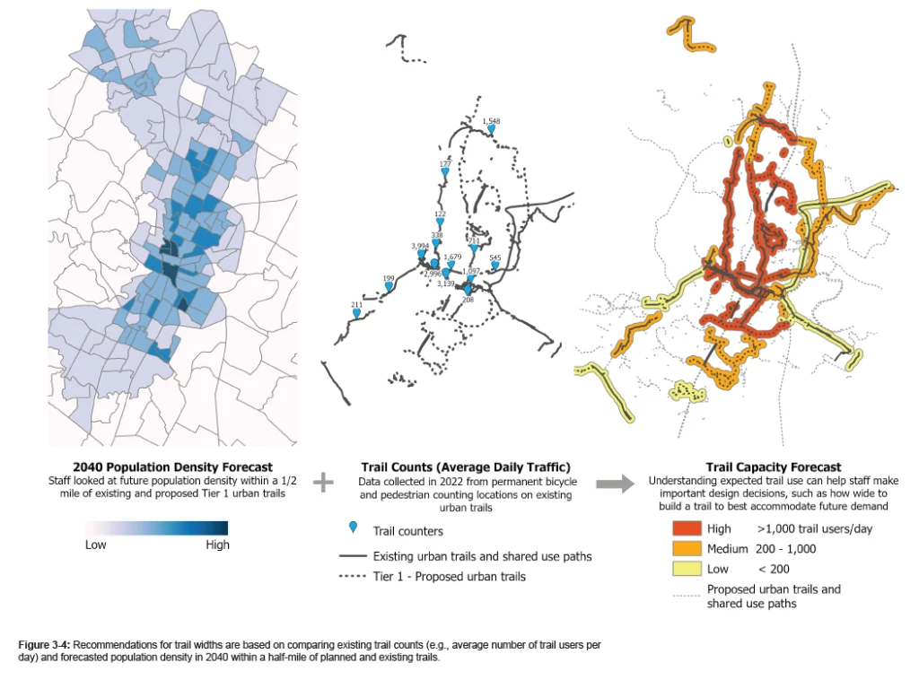
Determining Trail Width
The Design Guide presents two options for determining trail width: 1) forecasting trail capacity using population density and trail count data method and 2) the FHWA Shared Use Path Level of Service (SUPLOS) Calculator method.
The first method for forecasting trail capacity is a regional precedent adapted from San Antonio’s Trail Design Strategy, which projects future trail use by comparing existing trail use (i.e., recent trail counts) and anticipated population density within a half-mile of planned and existing trails. This method and the corresponding capacity map are illustrated in Figure 3-4. The second method, the FHWA SUPLOS Calculator is a nationally recognized best practice and a helpful tool for choosing an appropriate trail width given existing data or anticipated user volumes and mixes during peak periods of use. These two methods help determine not only trail width but whether dual track urban trails are warranted based on calculations. Dual-track urban trails separate pedestrians from people biking and using other faster wheeled devices, which increases comfort by reducing conflicts between users traveling at different speeds. The City of Austin strongly recommends providing dual-track trails wherever space permits.
Improving User Safety and Comfort
Issues:
- Safety of existing and future trail crossings due to conflicts with vehicular traffic.
- Concerns of personal safety in locations where there is limited visibility on trails, either due to visual obstructions such as overgrown bushes or lack of lighting, or the distance between trail access points
- Differences in the speeds of trail users—such as a person walking, a family biking with children, or a person bicycling long-distance for recreation, dog walkers and joggers—can create conflicts where space is limited.
Opportunity:
- Create consistent trail design standards applicable to all urban trails for both recreational and transportation trail users.
- Focus designs on safety and maintenance considerations that incorporate public feedback.
- Shared use corridor policies can outline clear guidelines for designing trails within rail or utility corridors.
3.2.2 Shared Use Corridors
Shared use corridors are active railroad corridors, transit lines, or utility corridors where there may be opportunities to add urban trails. The City and its
partners have had successes on past projects such as Country Club Creek Trail along a transmission line and Lance Armstrong Bikeway along a rail
corridor. There is interest in utilizing more of these corridors for multiple purposes.
A key to understanding and implementing shared use corridors is understanding the complexities of coordinating with utility companies, railroad companies,
and transit agencies. Implementing shared use corridors involves supportive legal policies and protections, partnerships, and design considerations.
Developing a set of shared-use corridor guidelines in partnership with utility companies and transit/freight providers can provide structure for pursuing urban
trails on shared use corridors. It is recommended to focus the guidelines on liability protections for the operating company and include design, management,
and maintenance standards for the City. See Appendix D for additional detail and recommendations.
It is helpful to approach these shared use corridors by the type of active right-of-way use, in order to determine differences in the development process, policy
and regulatory approaches, design guidance, constructability, operations, and maintenance. A summary of the benefits can be found in Figure 3-5.
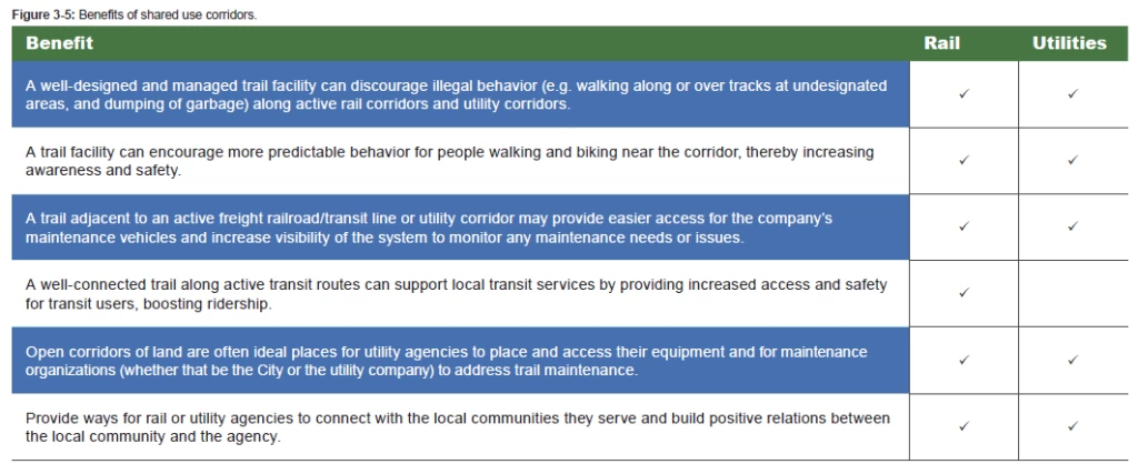
Rail Corridors
Shared use corridors with rail lines include both freight rail and transit. Design considerations for both types of rail corridors overlap, although each have unique approaches to allowing and building trails within the right-of-way. Nationwide, freight rail is the more common active right-of-way for shared use corridors. Class I freight rail lines (which are used for longhaul freight movement) are the most actively used. Transit lines, while not as commonly co-located with trail facilities, still account for a significant amount (40 percent since 20002) of shared used corridors with a significant growth trend.
Action Items
- Develop a set of rails with trails guidelines to provide structure for pursuing urban trails on corridors in partnership with freight operators and transit agencies.
Utility Corridors
Utilities that operate on long, uninterrupted stretches of land include electrical, telecommunications, stormwater, water and wastewater lines, and oil and gas. Occasionally, multiple utilities operate along one corridor. Although there is no national database that tracks the number of shared use trail/utility corridors and total mileage, it is understood that there are hundreds of such corridors totaling thousands of miles of trails within utility rights-of-way and/ or easements across the U.S. The type and location of the utility may have impacts on the shared use corridor. For instance, electrical lines and telecommunication towers may have little concern for topography; however, steep climbs will deter some trail users without proper design.
Action Items
- Develop a set of shared-use corridor guidelines to provide structure for pursuing urban trails on corridors in partnership with utility companies
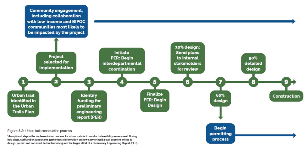
3.3 How a Trail Becomes a Trail
Preliminary Engineering Report
Once a project is selected for implementation and a funding source for a Preliminary Engineering Report (PER) is identified, the PER process is started. This PER process evaluates all the environmental constraints of the corridor including: topography, drainage, various soil types, tree canopy, wildlife habitat, floodplain, surrounding land uses, location of utilities, cultural assessments, critical environmental features, endangered species, property ownership, as well as several other elements.
Community engagement occurs as part of the PER process to understand community needs and preferences as related to the trail alignment. The preferred alignment for the trail is then selected based on the identified constraints, opportunities, and public input.
The trail then goes into the process of design. This design process is iterative and interactive.
Then project team engages multiple city departments and outside agencies throughout the design process. Coordination with departments and agencies typically occurs at 30% design, 60% design, and 90% design. Community engagement takes place at 60% design and community input is incorporated into the 90% design plans. 90% plans are submitted to Development
Services Department (DSD) for permit approval. DSD reviews for code compliance and leads the variance application process. When environmental variances are required, the project team also briefs relevant boards and commissions during this time. It typically takes a minimum of two years to design a trail, but the timeline varies based on
the complexity of the trail segment.
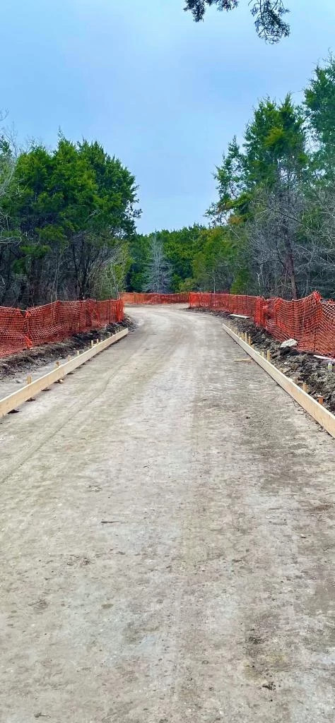
Construction
After design is complete and a permit is received, construction documents are developed. The documents are used in a bidding process to select a viable contractor for the construction of the trail. Trail construction
typically lasts from 12-18 months.
3.4 Feasibility Assessment
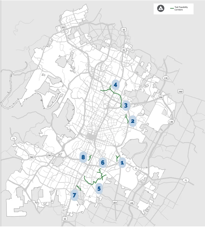
As described in Section 2.2, the Urban Trail Network includes urban trails identified in the 2014 Urban Trail Plan and those submitted by members of the community. These proposed trail alignments are conceptual in nature and significant research and engineering is required to move a trail segment forward into design and construction. Sometimes, during this research phase, the project team finds that due to environmental obstacles, limited real estate, or other barriers, an identified trail alignment cannot be constructed. To better inform which projects move forward first and the tradeoffs between them, 10 projects from the Proposed Urban Trail Network were assessed for their feasibility (i.e., ease or complexity of design and construction).
3.4.1 Project Selection
In determining which projects should be selected for feasibility assessments, Urban Trails Program staff focused on projects that scored highly in the final prioritization model that
have not already been studied. Staff also looked for an equitable distribution of projects, with a focus on projects located in Most Vulnerable and Medium-High Vulnerable Equity Analysis Zones as well as those located on publicly owned land. The trail corridors selected for feasibility assessments were:
- Montopolis Tributary Trail
- Little Walnut Creek Trail from E. 51st Street to Manor Road
- Little Walnut Creek Trail from IH-35 to 290
- Little Walnut Creek Connectors: Little Walnut Creek Trail (IH-35 to N. Lamar), Lamar Blvd to Bon Air Dr Connector, Rundberg Ln to Payton Gin Rd Connect
- Williamson Creek Trail Stassney to McKinney Falls State Park
- Bergstrom Spur to McKinney Falls State Park
- South Boggy Creek I-35 to Bluff Springs Rd
- Blunn Creek Trail from Oltorf to Bergstrom Spur
3.4.2 Assessment
The feasibility studies recommend trail routes and identify considerations for implementation. The focus of this work is to minimize impacts in sensitive environmental areas and constrained spaces and outlines steps for implementation. The feasibility assessments focused on:
- Route location and trail access points
- Key issues and challenges related to design and construction
- Property ownership and right-of-way needs
- Permitting and land use requirements
A schematic of the proposed route were developed for each corridor, which can be used as visuals during community engagement. Finally, an opinion of probable cost estimates is included for each trail corridor developed using standard unit costs with assumptions and contingencies noted. While these feasibility assessments are a valuable starting point for implementation, conditions are constantly changing and adjustments are expected to be needed as trails move into design. These feasibility assessments are intended to be a resource but a full Preliminary Engineering Report is anticipated for each project prior to trail design and construction. For more information on the assessments for each corridor, see Appendix F: Feasibility Assessments.
- Montopolis Tributary Trail
- Little Walnut Creek Trail from E. 51st Street to Manor Road
- Little Walnut Creek Trail from IH-35 to 290
- Little Walnut Creek Connectors: Little Walnut Creek Trail (IH-35 to N. Lamar), Lamar Blvd to Bon Air Dr Connector, Rundberg Ln to Payton Gin Rd Connect
- Williamson Creek Trail Stassney to McKinney Falls State Park
- Bergstrom Spur to McKinney Falls State Park
- South Boggy Creek I-35 to Bluff Springs Rd
- Blunn Creek Trail from Oltorf to Bergstrom Spur
3.5 Funding and Timeline
The Proposed Urban Trail Network includes 268 miles of proposed urban trails within City boundaries. While the City aspires to build the entire Proposed Urban Trail Network, the Urban Trail Network has been divided into three tiers based on prioritization as described in Section 2.4. This Plan has identified 94 miles (approximately one third of the network) as Tier 1, or high priority. To develop a high-quality and continuous network that provides a transportation alternative and works to achieve the ASMP goal of 50/50 mode-share by 2039, the Plan sets the goal of constructing all proposed Tier 1 urban trails within the next 20 years.
At an average estimated trail cost of $10 million per mile (2023 dollars, which includes but is not limited to design, right-of-way acquisition, permitting, and construction), additional funding at the amount of $860 million will be needed to construct the next phase of Tier 1 projects. Every trail project is unique, and current project costs range from $4 million to $40 million per mile depending on the complexity of implementation (e.g., number of bridges, length of boardwalk, creek bank stabilization, number of grade-separated or signalized intersections). The ability for the Urban Trails Program to deliver projects on an accelerated timeline is also heavily dependent on increasing internal City of Austin capacity across supporting departments concerning staffing, systems, and the processes for permitting.
Starting with a conceptual alignment, an urban trail project takes at minimum six years to implement, assuming funding is available for preliminary engineering, design, and construction. This Plan provides a 20-year action plan, with flexibility on what projects move forward on an annual basis. In collaboration with impacted communities, funds should first be allocated to projects in most-vulnerable and medium-high-vulnerable equity analysis zones as these areas have been historically underserved.
Action Items
- Construct all Tier 1 Urban Trails by 2043and seek leveraging opportunities for implementation of Tier 2 and Tier 3 urban trails.
Austin Mobility Bonds (2016, 2018, and 2020)
Through voter approved 2016, 2018, and 2020 Mobility Bonds, the Urban Trails Program received $109 million for mobility projects. This bond funding allowed the Urban Trails Program to ramp up the design and construction of priority projects from the 2014 plan. The ongoing bond funding also provided for growth in Urban Trails Program staffing, expanding from one full time employee in 2014 to five full time employees in 2020.
The Urban Trails Program has fully allocated all Mobility Bond funding to specific ongoing projects. Additional funding will be needed to construct the next phase of urban trails outlined in this Plan. Additionally, bond funding can only be used for capital projects and cannot be used for anti-displacement, management, or maintenance activities.
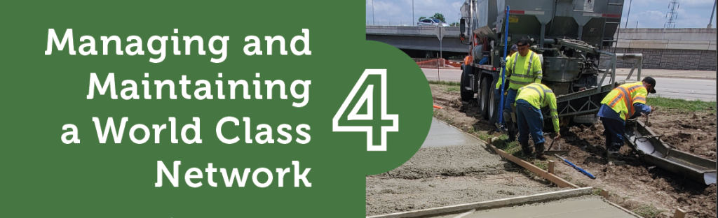
4: Managing and Maintaining a World Class Network
Achieving the Austin Strategic Mobility Plan (ASMP) goal of increasing how many people walk, bike, or take transit is not just about building more trails. The existing and future urban trail system also must be managed and maintained such that it is open and welcoming to use.
This chapter begins with strategies on programming the urban trail system. Through community outreach we heard that low-income communities and communities of color do not always feel welcome on urban trails. The goal of the programming strategies discussed here is to bring new and diverse users to existing and future trails and make trails welcoming for a wider array of Austinites.
Next, the chapter speaks to the importance of data, such as trail counters and mapping, in managing the trail system. Finally, the chapter ends with recommendations for a proactive maintenance plan, calling for an expanded maintenance approach that keeps up with Austin’s growing urban trail system.
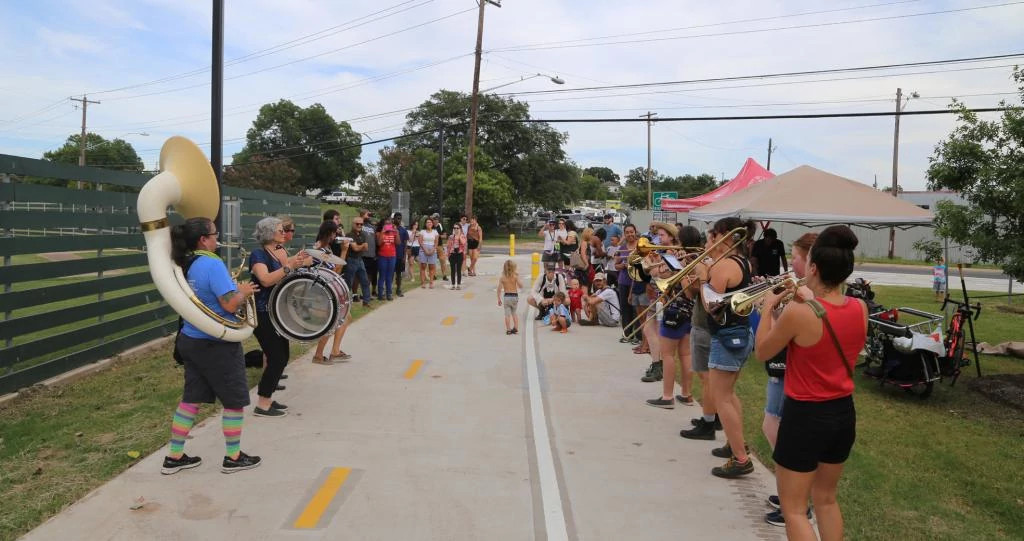
What we heard
“If I could say 5x this one, I would: Maintain sidewalks, urban trails, and bikeways so they are free of debris, overgrowth, cracks, and bumps.”
“Maintenance of paths is a big issue.”
- Community member feedback, Phase 1, September - October 2021
4.1 Programming
4.1.1. Creating Destinations
Urban trails should be designed not just as a route to get from one place to another, but as unique, comfortable, and identifiable destinations. Experiencing a trail as a destination can be achieved through wayfinding, gathering areas, and placemaking.
Adding wayfinding helps people navigate the trail system and creates a recognizable brand throughout the system. It also helps to define trails as public spaces where all people are welcome. Wayfinding can include maps, directions to nearby streets and destinations, mile markers, and other informational signage.
Destinations along trails can also make the trail corridor feel like a special place. These can include art installations, scenic overlooks, playgrounds and parks, creek access points, unique rest areas, connections to nearby businesses, performance spaces, nature trails and other elements that draw people to the space.
Managing and Maintaining Trails
- Issues:
- Some existing trail corridors are connected by decomposed granite trail, sidewalk and on-street bicycle infrastructure, and concrete trail. This difference in appearance along the trail makes it hard for trail users to know which way to turn and if they are still following the trail alignment.
- Access points to some trails are unclear, and in some cases can be mistaken for private property, which can intimidate potential trail users and in particular make BIPOC residents concerned about using them.
- Limited funding for maintenance means maintenance is often reactive, responding to 3-1-1 requests, rather than proactively inspecting trails for maintenance concerns.
- Encampments of people experiencing homelessness are often located in areas near existing or future urban trails.
- Opportunity:
- Trail Stewards can fulfill many roles, such as answering user questions, scouting for maintenance needs, and educating members of the public.
- A proactive maintenance plan can provide an equitable solution to urban trail maintenance and serve as a framework for annual budget requests.
- High-quality maps can provide information to the public and be used to track all assets related to urban trails, for instance location of bridges, signs, amenities, etc.
- Wayfinding and informational signage can help users navigate the trail system.
Opportunities to add these types of destinations should be considered on all existing and proposed trail projects. Currently, the Urban Trails Program allocates 2 percent of the construction budget of each project for placemaking. To implement placemaking the Urban Trails Program depends on partnerships with non-profits or the City of Austin “Art in Public Places” Program.
The Arts in Public Places Program has limited staff capacity and a set process and requirements for placemaking along capital projects. These factors limit what is possible for placemaking along urban trails. To allow a more fluid approach to placemaking, with amenities, play facilities, and green infrastructure considered along with art, it is recommended the Urban Trails Program lead city-initiated placemaking along trail projects.
The Urban Trail Design Guide: Appendix D provides more detail on incorporating these elements into trail design.
Action Items:
- Develop and implement a wayfinding plan for all existing and proposed urban trails.
- Establish a process to undertake placemaking initiatives within the Urban Trails Program.
The EastLink Trail Project
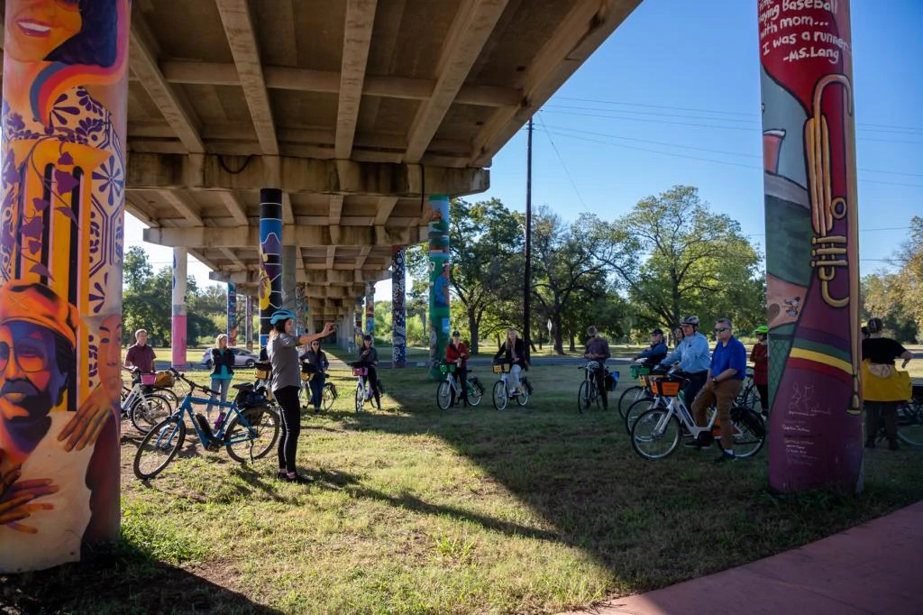
The EastLink Trail Project, an initiative led by Austin Parks Foundation (APF) and the Mueller Foundation, is using placemaking to remember the histories of East Austin and to create a cultural trail where all people feel welcome. The EastLink Trail is a 5.1-mile route in central East Austin that will connect Bartholomew Park to Lady Bird Lake. The Trail follows sidewalk, bikeway, and urban trail infrastructure using signage and wayfinding to highlight key community destinations.
APF collaborated extensively with the community to discuss what makes the area unique, its history, and how these concepts might be shown along the trail. So far, APF has dedicated much of its community outreach to documenting the oral histories of residents. The Pillars Project, located on Rosewood Avenue, is a series of murals based on these oral histories and is meant to demonstrate “how the history of a community can be its foundation for the future.”
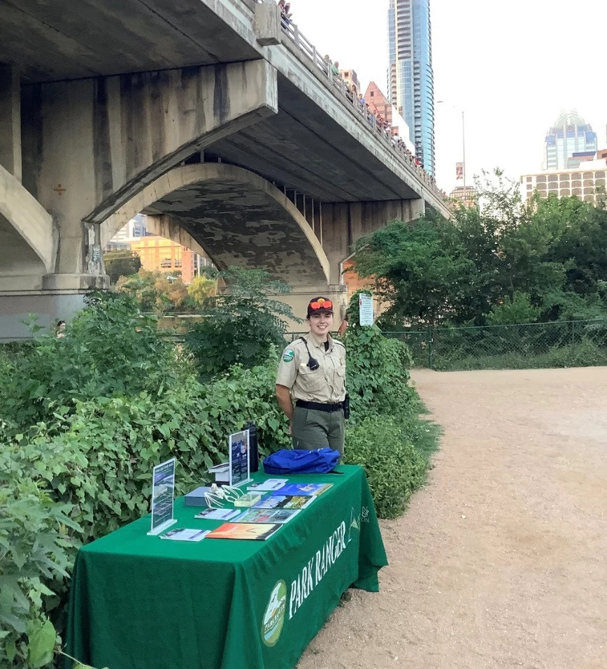
Trail stewards provide a friendly face to trail users and can fulfill many roles, such as answering user questions, scouting for maintenance needs as they arise, and educating members of the public. Trail stewards also provide a reassuring presence on the trail which can improve trail users’ perception of safety and increase the number of people using trails. A trail stewardship program could involve partnering with non-profits or volunteers or scaling up the City of Austin Park Ranger Program.
The City of Austin’s Park Ranger program, started in 2010, is housed under the Parks and Recreation Department (PARD). As of early 2021, only twenty park rangers patrol 330 parks and 253 miles of park trails.
While resources are needed to expand the program, there is opportunity to do so in a way that achieves the City’s goals of an equitable trail system. The Park Ranger Cadets Program partners with a local high school to provide a career path toward the ranger vocation with a focus on equitable community representation. A key part of the Cadets program is for rangers to reflect the local community and create a welcoming environment.
Figure 4-1: A trail ranger shares information on Ann and Roy Butler Trail.
A trail steward program could also serve as an opportunity to hire second chance employees such as the formerly incarcerated or members of the un-housed community.
As trail stewards could serve multiple purposes towards managing and maintaining the trail system, it is recommended the Urban Trails Program explore opportunities to partner with non-profits or PARD to implement a trail stewardship program.
4.1.3 Encampments
Similar to other cities across the United States, Austin has a large unhoused population. Some of this population lives within parks and other public spaces where they may be in close proximity to an existing or proposed urban trail.
When an urban trail is proposed through an undeveloped area where an encampment is already in place, the encampment needs to be relocated in order to construct the trail while keeping both the people experiencing homelessness and the construction crew safe. Prior to construction, multiple rounds of outreach to the encampment are needed to let those living there know of the upcoming project. Non-profit social service providers may offer assistance in outreach to the encampments, providing resources such as medical evaluations, bus passes, and housing assessments as resources allow. As the time for relocation gets closer, resources should also be provided at the encampment to assist with securing belongings during the moving process.
Citywide, more resources are needed to address encampments, both in terms of resources for outreach during relocation and for more long-term support services and housing. More sanctioned encampments, bridge shelters, and permanent housing can all help reduce the number of encampments along urban trails. The City of Austin established the Housing-focused Encampment Assistance Link (HEAL) initiative in 2021, intended to compassionately close a number of encampments in Austin by offering people experiencing homelessness a direct pathway to crisis shelter and opportunities to attain stable housing, sustainably reducing public camping in unsafe areas. The HEAL initiative has successfully closed encampments, providing resources and an alternative location to those that live there. However, the need for this initiative currently far exceeds the funding available. It is recommended that additional resources be provided to allow the expansion of the HEAL Initiative, or a similar model to partner with the Urban Trails Program when encampment relocation along existing or upcoming trail projects is needed.
- Action Items:
- Provide compassionate outreach to encampments when impacted by upcoming urban trail construction.
4.2 Data Management
4.2.1 Trail Counters
Trail counts provide helpful information for understanding trail activity in Austin. The regular reporting and interpretation of data will improve the City’s ability to deliver a network that is well designed, maintained and activated. Investment in the trail counter equipment, data management systems, and staff training is critical to implementing a successful trail count program. Trail counts can be used for:
- Measuring trail use, including monitoring trends each year to understand trail usage citywide
- Grant funding applications
- Demonstrating how better trail connectivity increases trail use
- Demonstrating the need for trail improvements due to high trail use
- Identifying trails with low use and asking why
- Understanding trail use before and after a new project is installed
In 2010, the City installed its first permanent, continuous counter in downtown on the Lance Armstrong Bikeway. Since 2010, the number of continuous count locations citywide has expanded to 38 locations and continues growing each year to include new bikeways and trails. The Urban Trails Program currently maintains 13 continuous trail counters and one portable trail counter for short duration counts.
A next step for the Urban Trails Program will be establishing a regular reporting mechanism, such as an annual trail count report, to share high-quality trail count data with the community and elected officials.
- Action Items
- Invest in a comprehensive system of counters combined with a work plan to install, monitor, and maintain the system.
Types
- Invest in a comprehensive system of counters combined with a work plan to install, monitor, and maintain the system.
Types of Trail Counters
There are two basic types of bicycle and pedestrian count methods: continuous counts (sometimes called permanent counts) and short duration counts.
Continuous counts and short duration counts are both necessary to develop a complete picture of non-motorized activity. At continuous count locations, data is collected 24 hours per day, and the counters are intended to remain in place indefinitely. Short duration counts occur over a limited period of time, ranging from a few hours to several weeks, and are taken using portable counters that can be deployed around the city at multiple locations to better understand bicycle and pedestrian use citywide. Continuous counts and short duration counts are both necessary to develop a complete picture of non-motorized activity.
A potential third type of count method is emerging. Researchers and practitioners have begun to recognize and explore the potential of shared data sources collectively referred to as “Big Data.” This type of data is typically crowdsourced or uses information generated from GPS-tracking devices—such as smart phones apps (Strava, MapMyRide, etc.), watches, and fitness trackers—to generate trends and patterns. It should be recognized that Big Data does have limitations, as it depends on trail users that have GPS-tracking devices which are not as common among low-income and BIPOC communities. The decision whether to use Big Data sources should always include an assessment of whether target populations are appropriately represented in the data.
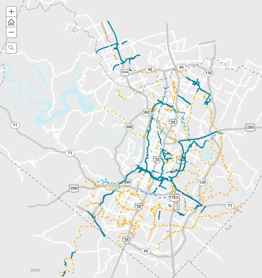
It is important to record and maintain high-quality GIS1 data for urban trails. The Urban Trails Program uses GIS data for: planning and program management; community engagement and education; and asset management.
High-level, conceptual alignments for urban trails are drawn in GIS to be used for planning and program management to better understand how to implement the Proposed Urban Trail Network. Trail alignments are regularly updated as projects progress and are used in ongoing coordination with other City work groups (e.g., Safe Routes to School, Sidewalks, Bikeways, Speed Management, Vision Zero, Corridor Program Office), nonprofits, and private development partners, where projects overlap.
Maps are used for community engagement and educating the public about urban trails. For example, the Urban Trails Interactive Web Map is a publicly accessible web map that allows trail visitors to see where completed trails are located and what upcoming projects are in progress across the city.
Maps are also used for recording and tracking urban trail assets for asset management and maintenance purposes. Maintenance staff need to understand where there are bridges, trail amenities, signage, changes in trail widths or surface types, and which agency maintains each section of the trail and its different components (e.g., surface, vegetation/mowing, lighting, etc.). Mapping in GIS is the most effective way to track all assets related to urban trails in one place with the goal of better integrating urban trails into maintenance tracking systems (e.g., Maximo for service requests and work order tracking).
- Action Item:
- Maintain comprehensive GIS data for public and internal usage
4.3 Maintenance
4.3.1 ADA Transition Plan
In 1990, the Americans with Disabilities Act (ADA) established the standard that all public facilities transition to accessible facilities. While City staff have considered and incorporated accessibility into trail plans and designs, a full ADA assessment of existing urban trails is warranted to understand maintenance needs for users who rely on assisted mobility devices. By focusing on ADA needs, the access needs of other trail users (a concept known as universal design), such as parents with children in strollers, will be addressed as well.
ADA Barriers and Proposed Methods to Remove Them
ADA barriers on trails include excessive vertical and/or cross slope, excessive horizontal openings due to pavement shifting, cracks and damage from tree roots, and protruding objects such as overgrown vegetation. Trails can also be inaccessible due to lack of adjacent ADA parking or an accessible route to the trail from nearby transit stops.
While all new urban trail projects are built to meet ADA standards, the existing urban trail system has not yet been assessed for ADA compliance. The Urban Trails Program does not currently have resources for a comprehensive assessment. Additional budget is needed to assess the condition of all trails managed and maintained by the City of Austin. The assessment is to be similar in scope to what is outlined in the City of Austin Sidewalk and ADA Transition Plan and Parks and Recreation Department (PARD) assessment.
Large cracks in trails and barriers caused by pavement shifting and vegetation overgrowth are currently addressed through regular trail maintenance. See Appendix G for suggestions on how to incorporate these maintenance considerations into a future maintenance plan.
More substantial barriers, such as excessive grades or lack of an ADA route to enter the trail, need to be identified and prioritized, and funds need to be identified for repair. As noted above, additional resources are needed to undertake a complete field survey of trail conditions. Once resources are identified, trails will be evaluated to determine ADA and Texas Accessibility Standards (TAS) compliance, as well as inspected for degradation, quality, and feasibility as a passageway (no permanent obstructions).
Once a condition assessment is completed, the Urban Trails Program will develop a comprehensive plan to address identified barriers. An increased maintenance budget will be needed to address an expected backlog of identified repairs, as well as to prepare for necessary repairs as the trail system continues to grow and age.
Schedule and Budget for Barrier Removal
If resources are provided, the Urban Trails Program could complete an ADA assessment of the trail system within the next two years and develop a comprehensive plan to address barriers, with associated budget needs within the next five years.
In an effort to start making progress towards barrier removal, an annual budget of $1 million per year is recommended to work on the known backlog until the assessment is complete.
Person Responsible for Plan Implementation
The Transition Plan implementation will be overseen by the City of Austin department director, overseeing the maintenance groups responsible for urban trails maintenance.
- Action Items:
- Complete comprehensive ADA assessments of all existing urban trails maintained by the City of Austin to inform maintenance planning.
4.3.2 Maintenance Plan Overview
As noted in Chapter 2, the Urban Trails Program has grown by over 30 miles since 2014 and will continue to grow as bond funded projects move into construction. An expanded maintenance program is needed to keep up with the growth in existing urban trails. Additionally, the City has historically addressed maintenance through 3-1-1 requests. The City has recognized that this approach is not equitable and a proactive maintenance plan is needed. The policy and program considerations for trail maintenance provided below are intended to serve as a starting point for building a maintenance plan specific to Austin’s urban trail system.
Maintenance plans should address the overarching components of user safety, comfort, and access, while also addressing how to operate a sustainable trail system and ensure ADA compliance. Based on best practice research, stakeholder interviews, and consultation with City staff and nonprofit organizations, the following are recommended topics to include in a future urban trail maintenance plan:
- Management Responsibilities, Roles, and Stewardship: Management responsibilities and roles should be clearly defined across departments and partners.
- Operational Maintenance and Standards: Routine maintenance is critical, especially when it requires collaboration across departments, agencies, organizations, and volunteers. Short- and long-term maintenance needs should be addressed, including debris and litter removal, drainage, clearance, signs and markers, trail amenities, vegetation, tread, structures, and safety inspections.
- Annual Evaluation Report: a summary report that evaluates the processes and practices used to maintain the urban trail system on an annual basis. The annual report should identify the number of maintenance staff, hours spent performing maintenance activities, miles of urban trails that were repaired, and budget spent on trail maintenance. It should also highlight key projects or major milestones,
- Performance Measures: a series of performance goals, measures, and procedures for monitoring the progress of maintaining the current and proposed network. To build public trust, the identified metrics should be transparent and easily accessed, understood, and tracked.
For more information on the maintenance plan, see Appendix G: Maintenance Policy and Process Memorandum.
- Action Items:
- Create an operations and maintenance annual budget dedicated to the Urban Trails Program to include dedicated staff time to maintain functionality standards and contingency funding for emergency repairs.
- Develop a proactive maintenance plan for the growing urban trail system.
4.4 Partnerships
Partnerships are key to leveraging resources to build, program, and maintain the urban trail system. City departments, public agencies, and non-profit partners have different strengths and capabilities that all contribute to the shared purpose of creating an enjoyable trail experience for all. Building and supporting these partnerships can streamline approvals, clarify maintenance responsibilities, and display a shared value of trails to the public.
To understand the responsibilities and partnerships that go into efficiently managing and maintaining Austin’s urban trails, Urban Trails Program staff conducted informational interviews with key City staff and non-profit stakeholders. The interviews were informative in understanding management and current maintenance practices.
4.4.1 Public Partnerships
Public partners are referenced throughout this Plan as they are key to the success of the urban trail system. Figure 4-3 provides an example of frequent public partners and when each partnership is needed. As every trail has unique considerations, this table is meant to serve as a snapshot of possible partners and is not inclusive of all partnerships needed for the construction, management, and maintenance of the urban trail system.
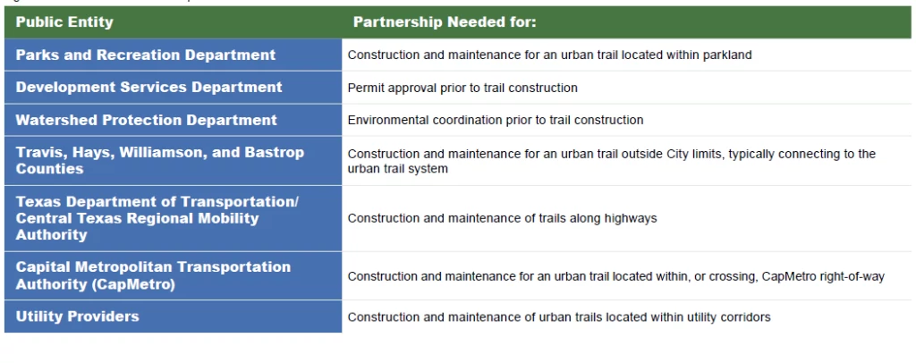
Interdepartmental agreements, interlocal agreements, memorandums of understanding, and other legal documents establish these partnerships and include the roles and responsibilities of each partner as related to construction, management, and maintenance. As the urban trail system has grown, so has the number of established legal agreements. For instance, rather than one interdepartmental agreement for trails within parkland, each trail has a separate agreement. It is recommended to streamline these agreements by creating one Memorandum of Understanding (MOU), or similar document, per partnership, to improve consistency and help organizations and agencies better focus their time and efforts.
- Action Item:
- Create streamlined Memorandum Of Understanding with public partners.
Building Partnerships
- Issues:
- Many partners are needed to build and maintain the urban trail system. In some instances, this can lead to unclear roles and responsibilities for trail management and maintenance.
- Construction of the urban trail system also requires approval by a wide array of partners who may have competing interests and priorities in the corridor.
- Lack of partners that represent low-income and BIPOC communities.
- Opportunity:
- Streamlined agreements for the planning, construction, management and maintenance of trails can clarify responsibilities, increase collaboration, leverage funding, and demonstrate a shared value of trails to the public.
- Community led partnerships can expand the capacity of city agencies.
- Community organizations that represent low-income and BIPOC communities can join the Urban Trail Stakeholder Group
4.4.2 Non-Profit Partnerships
Non-profit partnerships are also crucial to developing, managing, and maintaining the urban trail system. Figure 4-4 provides a sample of non-profit partners, but is not inclusive of the many non-profits that support the urban trail system. These specific partners were called out in Council Resolution 20200220-045, which established the Urban Trail Stakeholder Group, discussed in Section 4.4.3.
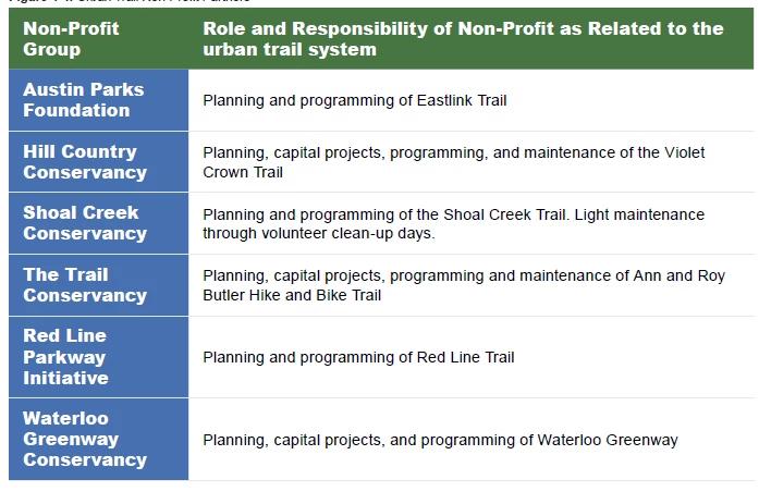
CapMetro
To reach the ASMP goal of 50-50 modeshare, the City of Austin and CapMetro have partnered to make it easier to walk and bike to transit stops. CapMetro approved design for Austin to Manor Trail, the first urban trail to be located almost entirely within CapMetro right-of-way. Work is also underway on a joint initiative to create a vision for Red Line Trail, proposed to run along CapMetro’s MetroRail Red Line from Austin to Leander.
Additionally, the City of Austin and CapMetro have partnered to expand MetroBike, a local bikeshare system. Coordination is underway to determine where new stations can be strategically placed along existing or future urban trails. With a fully electric fleet proposed, bikeshare may be a more enticing option for those with varying levels of physical fitness and for those traveling in the Texas heat.
Each non-profit partner has different strengths and capabilities, and partnerships need to be tailored accordingly. Improving partnership logistics, such as reducing burdensome legal requirements and liability costs for non-profits, can increase their capacity to build, manage, and maintain trails. A framework for establishing formal partnerships with non-profits already exists through the City of Austin’s Parks and Recreation Department “Community Parknership Initiative”. This framework provides clear roles and responsibilities for the City and the non profit “parkner,” which improves non-profit operations and shifts the focus towards their trail-oriented mission. As of plan adoption, the “Parknership Initiative” consists of three full time employees to track partnerships and maintain consistent communication. To formalize further non-profit agreements through this initiative, additional
resources would be needed. While the Urban Trails Program’s existing nonprofit partners have been key to the Program’s success, it is important to acknowledge they are historically primarily white organizations. To equitably develop and manage the urban trail system, the Urban Trails Program needs to develop new partnerships with community organizations that represent and serve low income and BIPOC communities. To engage more diverse community groups, childcare and compensation for time and expertise may need to be provided.
Action Items:
- Build and formalize partnerships with other public agencies and non-profits to enhance implementation, maintenance, and management of urban trails.
- Build partnerships with community groups that represent and serve low income and BIPOC communities.
4.4.3 Urban Trail Stakeholder Group
To bring many of the public and non-profit partners together for improved coordination, in 2020, City Council passed Resolution 20200220-
045, which directed the City Manager to create an urban trails stakeholder group. This group is comprised of representatives from City departments and non-profit partners to examine and make recommendations on how to improve the administrative processes and requirements associated with the design and permitting of urban trails.
One of the process improvements recommended was to establish quarterly stakeholder group meetings and include executives from relevant
departments. This meeting series has been established and is focused on improving coordination within City departments and between City departments and non-profit partners. It also provides a platform to address potential obstacles in urban trail system development at the executive level, with staff support, as they arise. It is recommended to continue these coordination meetings and bring in new partners that represent and serve low-income and BIPOC communities.
Action Items:
- Continue quarterly Urban Trail Stakeholder Meetings and look for opportunity to invite new partners that represent and serve low-income and BIPOC communities.
Appendices
- Appendix A: ATX Walk Bike Roll Process Summary
- Appendix B: Urban Trail Network Field Work Report
- Appendix C: Urban Trail Network Maps, Scenarios, and Prioritization
- Appendix D: Urban Trails Design Guidance
- Appendix E: Shared Use Corridors White Paper
- Appendix F: Feasibility Assessment
- Appendix G: Maintenance Policy and Processes