In 2022, the Austin City Council requested that we prepare code updates to protect the Colorado River downstream of Longhorn Dam. We recommended updating erosion protections in Austin's Land Development Code and associated criteria manuals. The soils downstream of Longhorn Dam are sandy and easily wash away. We are already seeing roads, pipes and even buildings threatened. Code updates can help prevent new problems in the future as this area continues to develop. Austin City Council passed the ordinance on March 27, 2025.
Summary of Updates
There are two main aspects to the proposed updates to the Land Development Code and drainage criteria:
- Widening the area where an Erosion Hazard Zone Analysis is required. Use this interactive map to look up your property. Note that the Erosion Hazard Zone will remain at 100 feet for building permits for a single-family home within the City of Austin.
- New requirements for discharging stormwater into the Colorado River.
- Requirement for Erosion Hazard Zone Analysis
-
Currently, to receive a building permit within 100 feet of a creek or the Colorado River within the City of Austin, you are required to provide an "erosion hazard zone" analysis. If the analysis shows the proposed building is within the erosion hazard zone, the area along waterways most prone to bank erosion, then protective measures (“works”) are required. This is to prevent the building from being damaged or destroyed if the riverbank gets washed away or by other catastrophic erosion.
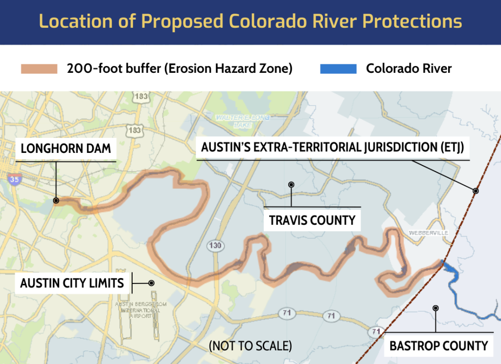
The proposed code update would widen the area where an analysis is required from 100 to 200 feet for the Colorado River, downstream of Longhorn Dam. For building permits for single-family homes the current 100-foot requirement will remain in place.
- Who’s Most Affected: Those seeking to redevelop and agencies or developers planning a new utility line adjacent to the Colorado River.
- What’s Allowed: Decks, pools, storage sheds, fences and trails. Hard surface trails will continue to be allowed, as they are today, with an erosion hazard zone remaining at 100 feet from the river bank.
- Measured From: The edge of the Colorado riverbank, also known as the Ordinary High-Water Mark. This is a technical term used for consistency of measurement.
- Getting into the Weeds: The requirement for an erosion hazard zone analysis stops on the far side of a public road. New public roads will be disallowed within 200 feet of the riverbank except for approved river crossings.
-
Affected Code: Existing Land Development Code section 25-7-32.
- Calculating the Erosion Hazard Zone
-
If an erosion hazard zone analysis is required, here are some technical requirements:
- Applicants must supply LIDAR or hydrographic data that determines the toe of slope. The erosion hazard zone starts at the “toe” (bottom) of the riverbank and goes inland at a 4-to-1 slope. For single-family building permit applications, the applicant may use the topographic information in the Property Profile Tool to locate the lowest elevation.
- All subsurface infrastructure must be below or outside the erosion hazard zone.
- For subsurface infrastructure proposed beneath the river itself, applicants must supply hydrographic data determining the elevation of the thalweg, the deepest part of the river bottom.
- Bridge footings or underground utilities crossing the river must be at least 20 feet below the thalweg unless they use geotechnical methods to demonstrate a non-erosive design.
- Discharging Stormwater
-
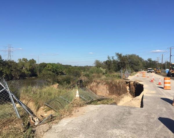
Deep canyons and gullies can form where stormwater is concentrated and discharged into the Colorado River, due to the sandy, highly erosive riverbanks. These canyons can rapidly expand inland and threaten homes, businesses, roads, and other infrastructure.
The Land Development Code already bans discharging water in a way that causes erosion. We are working on updates to the criteria manuals. The criteria manuals provide technical requirements and specifications when designing outfalls.
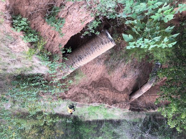
This canyon was formed over the years by stormwater discharged from these pipes, resulting in failure of the pipes and slopes.
Location
The proposed code updates would only apply to the Colorado River from Longhorn Dam to the edge of Austin’s extraterritorial jurisdiction.
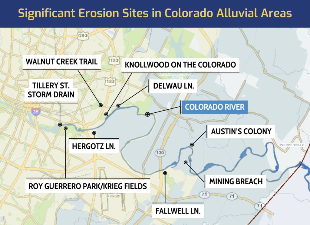
Erosion Sites
Erosion problems can be expensive and sometimes even impossible to repair or mitigate. Millions of dollars in public money has already been spent on erosion problems in alluvial areas by the Colorado River.
Process
We notified property owners of the proposed updates and conducted two public meetings. There were also public hearings and/or presentations at the Environmental Commission, Planning Commission, City Council Climate, Water, Environmental and Parks Committee and the Austin City Council.
Documents
- City Council Resolution
- Public Meeting Presentation, February 2025
- Recording of Public Meeting, February 2025
- Item 84 on March 27, 2025, City Council Meeting Agenda
Questions?
Please reach out to Matt Hollon at 512-974-2238 or send Matt Hollon an email.