Guest Post: Austin students examine the Heat Island Effect
Nature in the City is handing the keys over to local high school students and their teacher today. They worked as teams to compare heat potential in different neighborhoods around Austin. We hope you enjoy seeing their work as much as we have.

The assignment
In this blog post, you will find the work of High School Environmental Systems students from Cedars International Next Generation High School to answer the question, "How can we as ZIP Code representatives defend Austin's Urban Forest Plan using the laws of thermodynamics?"
The environmental science teacher, Stephen Carroll, tasked 11th and 12th-grade students to investigate structures in the Austin area’s ZIP Codes that trap heat, using Austin’s Urban Forest Plan as a guide. Students spent 3 weeks learning about how the laws of thermodynamics can be seen in capturing and transferring heat. Some visited heat islands that you can see from Google maps to personally experience concrete absorbing heat. In the students' writing, you will see how our city’s infrastructure amplifies hot summers, resources for you to help our city, and students’ experiences with green space inequality.
- How our home has been affected: 78753 (Allison, Sonia, Lorenzo)

-
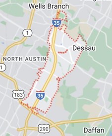
Overhead view of 78753
This article is related to the 78753 ZIP Code. We talk about the laws of thermodynamics, the different spheres, and how it all relates to our ZIP Code. We also incorporate the Austin Urban Forest Plan, our social media post for APF, and how construction and littering affects our species. As well as how heat islands affect our environment and our everyday life. We chose this ZIP Code because two of our members live in that ZIP Code and one has lived there. We can all see how this affects us in our everyday lives.
The second law of thermodynamics explains how it’s a lot easier to be messy than to be organized. The second law has a huge connection with the 78753 area, because our area has many heat islands. With heat islands, there’s a higher chance of littering and construction occurring. Littering and construction have a big effect on us,our environment and species. We continue to build structures for us, but we destroy our species ecosystem. The salamanders skin tends to be very sensitive, with all the littering and the construction pollution really affects their everyday lives. It has gotten so bad that they are now considered endangered species. With construction we construct more buildings and cut down trees like the juniper tree, it’s affecting our golden cheeked warblers. We cause them to migrate somewhere else. We have different types of birds in Texas but the golden cheeked warblers are only native to Texas and are considered endangered species.
The third law of thermodynamics explains when temperature approaches zero it means we will have no energy. I believe that we will never reach that point. Energy is used in our everyday life, for instance when we walk. When walking you push the street, you apply action force on the street's ground, and the reaction force moves you forward. Technology is also part of our use of energy. Energy gives the foundation for heat engines, power plants, chemical reactions, refrigerators, rockets and many more important concepts and projectile devices that we use on a everyday basis.
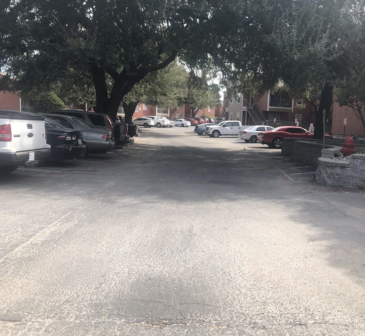
Residential Road in Woodland Heights Apartments
First law of thermodynamics explains energy can neither be created nor destroyed and you notice that with heat islands. The energy from the sun has to go somewhere and in areas with a lot of asphalt, the heat transfers into the pavement. The pavement transfers the heat into the air and surrounding area, causing heat islands. Heat islands are structures that absorb the sun's heat more than natural things. Heat islands can cause many problems; health, building, ecosystems problems, and etc. For example the heat from the asphalt can transfer into the pads of dogs' feet burning them. Shaded areas from plants or structures would lower the heat from the sun going into big heat conductors. In the 78753 places with rain gardens they have cooler temperatures. Those areas also have cooling structures. Due to heat islands in 78753, there’s an increase of dangerous dogs. Increase of dangerous dogs is because of the low amount of cooling areas and plant life.
Heat transfers in different ways in the spheres and affects heat islands differently. Conduction is movement of heat energy through solid atoms. We see conduction in our daily lives, when we go into copperfield park we see a lot of lizards and many other species. Lizards warm up their belly with the hot rocks from the park. Convection is movement of heat through liquid and gasses. Convection is when rainfall and thunderstorms occur, clouds are formed when water in the ocean gets warmed and rises up. These warm water droplets saturate and lead to the formation of clouds. As the clouds develop bigger, These large clouds which are referred to as cumulonimbus result in rainfall and thunderstorms. Advection is gasses transferring heat to other gasses. The motion of warm and cold air bodies (i.e., hot and cold fronts). Last radiation transfers heat through light. Think of the electromagnetic spectrum for radiation. Being aware of these different heat transfers can help you better understand how heat works in the first place. If you have more of an understanding of how heat works it can help you have a better understanding of heat islands.
How can I help?
There are many ways you can help reduce the heat in heat islands. We, as a community, can plant more trees and more native plants. By picking up our trash or hosting a community cleanup, it can make a huge change and help our area improve on saving our endangered species! Pushing for more cooling structures helps as well!! Overall, make sure to always keep the laws of thermodynamics in mind!
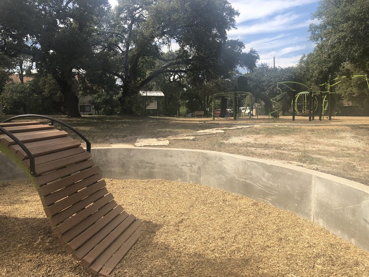
- 78653 (Zaria, Luciana, Debra)

-
Heat Islands are highly concentrated areas of heat that can form in high areas of poverty, the roofs of buildings in populated cities and towns, and especially large, empty parking lots. These heat islands can cause increased temperatures, heat related illnesses, and burns on your puppy’s feet! Heat islands form when then the sun shines directly on a conductive surface heating it up to such a high temperature it’s hotter than the air temperature in that area!
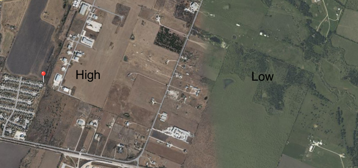
Aerial view of Manor, Texas showing areas of high and low heat island potential
For example, Half of Manor is an area with a high density of trees as well as a dry, open plains with a mix of heat islands and lots of open nature. But what makes these two areas in the same zip code different? Well the answer is pretty obvious when you think about it. Trees. But you are probably thinking to yourself, ‘Trees? How do trees make heat islands go away when they just stand around?’ Well first, trees provide shade to surfaces that hold onto the sun's energy all day and can drop the surface temperature up to 5-7 degrees! That number may sound small but imagine if we had a whole area filled with trees! Now that would make a difference!
We had the task of discovering a way to make all of Manor the same nice, shady, green and the best way is adding more trees! By shading all the highly concentrated areas of heat we can cool down the surface areas, preventing some of these heat islands from forming while making our area more green and beautiful!
The best trees to use are native species as they’ve already adapted to the environment and are low maintenance such as Mexican White Oak) and chinkapin oak.
- 78732 (Aline, Alex, Joseline)
-
Within ZIP Code 78732, heat islands are a rarity. This is due to a multitude of factors such as the surrounding environment, the large number of trees, and the lack of human activity. For context, heat island is an area of high temperature, and can occur due to the materials used in construction,a lack of shade, or human activity.
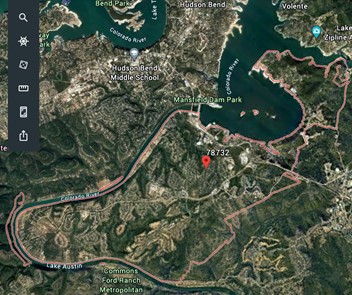
Aerial photo of ZIP code 78732 in Austin, Texas
So what causes heat islands? Well many things can contribute to heat islands. Human activity such as construction, landfills, and factories or airports. Yet ZIP Code 78732 has few heat islands. This can be attributed to the Lack of construction, meaning that trees that provide shade are not being torn down, nor are additional roads or buildings that can conduct heat are being built. Which also means that the future of this zip code is safe from gaining heat islands. However ZIP Code 78732 is composed of high income households that make over $200,000. Which means they can afford to maintain the wildlife around their homes since they can afford the costs. Additionally, Studies have shown that high income areas have less heat islands than low income areas.
As explained earlier, trees play a part in heat islands. More specifically, they block radiation, which is the transfer of energy through waves. By creating shade, trees are keeping asphalt and concrete from quickly absorbing heat, which leads to cooler temperatures. Additionally, trees are a part of the biosphere, which encompasses all life. On the other hand, the geosphere, which is the ground, is left relatively untouched in this zip code, which leaves animals natural habitats intact and has a smaller chance of creating heat islands.
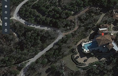
Aerial photo from ZIP Code 78732 showing the high amount of tree cover
Zip Code 78732 has few heat islands, but why is that? The main reason is that this ZIP Code is most likely due to the number of trees.
Zip Code 78732 is a high income distraction with a lot of trees, and little human expansion. With many trees and few structures, heat islands caused by radiation are less common. Trees provide shade to the ground, which blocks light, radiation from warming the ground, thus keeping the temperature of the area cool. Additionally, the second law of thermodynamics dynamics states that disorder in a system will lead to more disorder. This is not a problem for ZIP Code 78732 as it is not disorganized, and that won’t change in the near future due to Lack of construction which may contribute to the second law. From what we learned from Studies, income and heat islands may also be correlated.
How can you help reduce heat islands? There are a few ways, such as green roofs, which is planting grass or plants on your rooftop. Or using cool pavements and roofs which are made of materials different from the usual materials that absorb heat quickly.
- 78744 (Tyler & Dulce)

-
In the 78744 ZIP Code, a beautiful and lush area of Austin, heat maps look very different compared to places nearest to the inner city. The utilization of natural landscape can be seen in places such as McKinney Falls State Park and surrounding areas. In more residential living spaces however; the trees, shrubbery, and flowers blend into the background. Concrete plains, which retain a lot of heat, are more common than you think. Neighborhoods in the 78744 area promote the idea that it is a “green haven” and the houses that sell for the most money have a lot of shrubbery and natural river and creek runoff nearby.
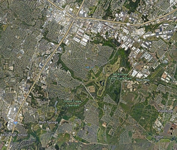
Aerial photo of ZIP code 78744
This is not always the case as urban sprawl plagues Austin resulting in wide concrete roads, highways, parking lots and tree removal. Most of the “inner” area of the 78744 ZIP Code is full of trees and a lot of greenery. In the outskirts there are more open areas; for example, the location of Ojeda Middle School is very open with not a lot of trees. This portion of 78744 is already trying to prevent heat islands by planting trees in the surrounding areas, however they are too small to provide a consistent and large source of shade.
- 78723 (Sabine, Jaden)
-
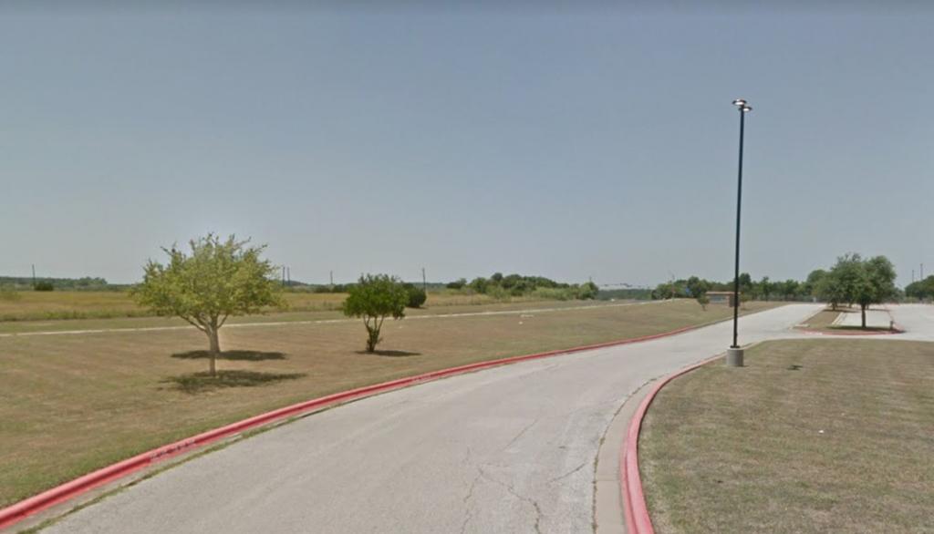
When we explore the east central zip code 78723 we encounter some unique circumstances. While this area is wealthier than most other ZIP Codes in Austin, it still suffers from overheating. Why? Due to a few reasons. Firstly, overcrowding; the entirety of the zip code (but particularly the Mueller area) is highly overpopulated and houses in the residential area are so close together they are nearly touching.
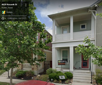
Houses at Mueller Development are closely spaced, contributing to heat island effect
Each house’s air conditioning unit emits hot air molecules, which bump up against the molecules of the air outside which raises the overall air temperature, a process otherwise known as advection. Another contributor is concrete construction lots which are in abundance because of the constant expansion. The exposed concrete in these lots can trap heat and reemit it into the air through conduction. The first law states of thermodynamics that the heat in the concrete will not disappear but will instead dissipate into the air over time.
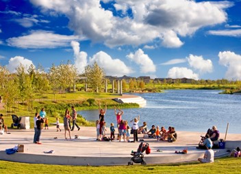
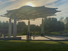
Pavement in Mueller Lake park added to the heat island. Adding a shade canopy has reduced this effect.
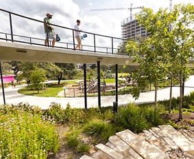
Thankfully, Mueller has already started to reduce some of its heat islands! Recently, a shade has been constructed over the large concrete pavilion near Mueller park. This addition blocks and reflects radiation so the concrete does not absorb heat. It would be ideal if the 78723 zip code continued to add shades over other heat islands in the area. Providing shade doesn't have to be as boring as just adding a cover over an area, there are many creative ideas, even some that already exist in Austin! Planting large native trees provides both shade and helps restore the native ecosystem, which is something Austin desperately needs. Another creative idea we’ve seen from exploring Austin parks are Waterloo park’s “floating pathways”. These are raised walkways that conveniently shade the area below!
For the issue of close together houses, while we cannot change the layout of homes that have already been built, we can suggest adding more space between any new houses built. For example, my neighborhood in 78653 has an area where the houses are really close together, the streets are really tight, and cars are cluttered on the sides of the street. In the new subdivision I live in called Presidential Heights, the houses are more spread out with wider designed streets. It may seem like spreading out new houses would never happen because less houses is less profit in the eyes of construction companies, but houses with large yards and neighborhoods that feature green spaces are shown to have much higher property values.
I hope some of these ideas can be implemented in the next few years. I think it would make me much more likely to visit 78723. To close out, we hope these solutions harnessing the power of thermodynamics can help 78723 to improve their methods for the future!
- 78741 - Dalia, Braden, Siler
-
78741, a beautiful area on the edge of the Colorado River and the Colorado River Park Wildlife Sanctuary. Despite the greenery, this area contains harmful construction, too hot to handle areas, and highly traveled roads. Our hope for this article is to give information and clarity needed to act on these issues.
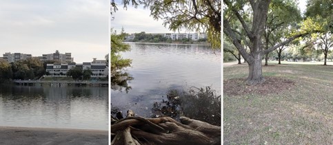
Austin's 78741 ZIP code includes open, sunny water; shaded riverbanks; and large trees that provide shade
Construction has increased in the expanding City of Austin. As any city that is expanding as much as Austin, we identified construction as a problem. Since it’s east of Downtown, 78741 is a desirable area to live in. From our research, here are the number of permits received for new buildings in the area (please keep in mind that this doesn’t include types of permits):
- 1,491 single family houses
- 92 two family buildings
- 495 three and four family buildings
- 7,242 five and more family buildings
- 510 mixed use buildings
- 127 secondary apartments
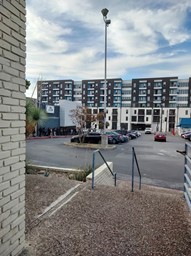
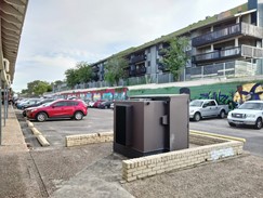
Apartments are common in ZIP Code 78741, leading to more heat buildup
Energy can neither be created nor destroyed, it can only transform. This shows up in our ZIP Code through energy put out by construction companies, roadways, etc. That energy will take a while to leave our area and could cause problems in the future. Every construction project uses fossil fuels (such as gas and diesel) which damage our atmosphere. It can also damage our water ways by pollution. This is particularly harmful in an area so close to the Colorado River, Austin’s main water supply.
There are lots of high traffic areas in our ZIP Code, including Emo’s. Not to pick on this Austin staple, but Emo’s alone can rack up to 1,700 people per concert (max capacity). Let’s say it’s their busiest concert and they hit their capacity. If we’re estimating around two people per car, that’s still 850 cars PER CONCERT, not including tour busses and staff cars.
Like construction vehicles, cars release greenhouse gases (mostly carbon dioxide). This gets put out heats up our atmosphere and roadways. When a car drives on a road and heats it up, that thermal energy spreads to other parts of the ground, which can cause damage to green spaces in the area. Keep in mind, our ZIP Code area is relatively walkable!
The majority of our ZIP Code is apartments and roads. Despite the greenery seen, we are still a high risk ZIP Code according to Austin’s Urban Forest Plan. If you’re curious on how you can help, you can take a look at Austin’s Urban Forest Plan for more information!
About the Authors:
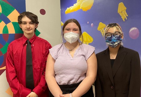
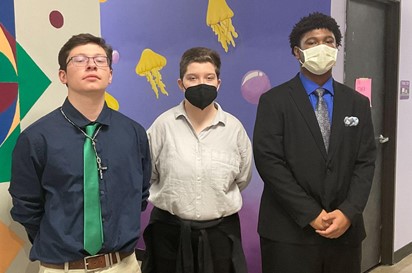
Siler - Hi I’m Siler Wooster. I’m a senior at Cedars International Next Gen High School. I wanted to choose this zip code because I wanted to analyze a high priority area (according to Austin’s Urban Forest Plan). This area also contains Emo’s concert venue! Which I’ve been to several times, so I’m relatively familiar with the area.
Dalia - Hello I’m Dalia Rodriguez. I’m a Junior at CING High School. With this blogpost I wonder if Apartment buildings could create green spaces on top of roofs or balconies. The zip code that we focused on convinced me to eat with my family in El Taquito.
Braden - Hello my name is Braden O’Malley and I’m a junior at cedars international. I’m curious what the most efficient way to cool and deal with heated areas is.
- Low Priority Space: 78749 - Kaleob, Joseph, Ainsley
-
We looked at the 78749 ZIP Code to see what a low priority area for the Austin Urban Forest Plan would look like.
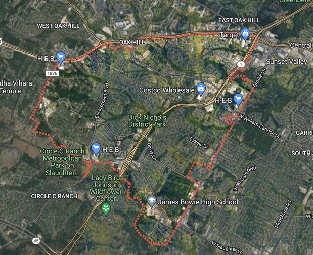
Aerial photo of Austin ZIP Code 78749
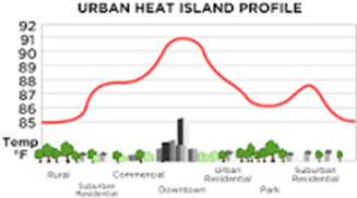
A low priority area means there is enough trees and forage in the area to cover areas with shade. A residential area with many trees, with minimal space between the buildings and the streets, as well as a green space with a park in the middle is what the area be looking like. The only areas of heat, or heat islands as shown below, are on the borders of the area and there are only 5 major/obvious heat islands. This pictures shows how hot it can get in certain areas. Heat islands are when the area heats up due to certain things.
Urban Heat islands can be reduced by vegetation and green roofs. The vegetation such as trees provide shade/cover to the roads and sidewalks that exist. This prevents the sidewalks and streets from heating up too much, due to the shadows. It also provides oxygen to our atmosphere, as well as pollen for bees. Our particular zip code is very green and to reduce some of our heat islands we could plant some trees in parking lots and or have giant mist blowers in the heat island to produce more moisture in the air.
The area has 2 major environments called the geosphere and the biosphere. The spheres represent the types of environments with the majority being one geography feature such as water or ice. The geosphere is mostly natural terrain such as mountains, canyons, concrete, etc.
The next thing is the biosphere which is mainly focused on living organisms such as humans, animals, bacteria, amebas, etc., which is very visible from the amount of residential spaces in the area. A diagram is shown above to show the differences. Both of these spheres have interactions with each other through energy in 4 different ways. Conduction, Convection, Radiation, and Advection.
The geosphere also has other spheres in it like the cryosphere, the hydrosphere, and the atmosphere which are all connected in their own ways. Such as, there would be no cryosphere without a hydrosphere.
Energy transfers between these 2 spheres in many different ways. Conduction happens when you walk your dog on hot concrete. Your dogs feet molecules touch the concrete molecules and heat transfers from the concrete to the dogs feet. Causing your dog to pick up its legs higher than normal. Convection would happen if people have pools next to each other which would keep the area at a constant temperature. Advection would happen if one of the heat islands were packed and the heat from the cars CO2 emissions keep the area hot. Finally, radiation is a lot more prevalent because it happens when the sun beams down on anything.
- Albedo and Heat Islands: 78721- Daniel

-
There is a surprising amount of tree coverage in my ZIP Code. There is a park called Givens District park and the green belt which sandwich the two lesser vegetation spots. There are two main spots where there are a lot of buildings with no vegetation. In my ZIP Code (78721) there is a lot of urbanization, but they will not overtake the green belt East Boggy Creek and the park in my area. It is a place for people to explore nature but still be reminded that the city exists because of the highway 183 Toll.
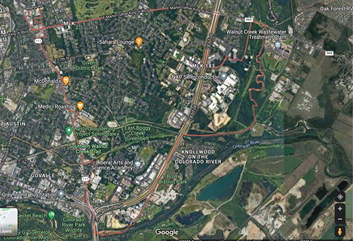
ZIP Code 78721 has a surprising amount of trees, but also some development
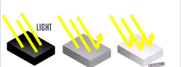
Tree cover is important to keep the surface temperature cool and the resting temperature lower. A phenomenon called albedo also contributes to surface temperature by the materials that light bounces off of. For example, have you walked on new asphalt and felt really hot, but when you get to grass it gets cooler.
Adding more trees, keeping a tree inventory, and managing is important to keep neighborhoods green and communities cool. Increasing trees will help decrease the amount of light absorbed into streets and keep the light reflecting into the atmosphere with a convection effect from the reflection of material to the atmosphere.
 This article written by High School Environmental Systems students at Cedars International Next Generation High School.
Thank you for taking the time to read our work. If you have any questions about our work or school, feel free to contact Stephen Carroll.
