
Stretching from Waterloo Park to Lady Bird Lake, the Waller Creek Tunnel helps reduce the risk of flooding in downtown Austin.
The tunnel reduces the size of the floodplain along Waller Creek. In doing so, it helps revitalize the eastern part of downtown. This area is called the Waller Creek District.
The tunnel is approximately 5,600 feet long. It lies 70 feet below the surface and ranges in size from 22 to 26 feet in diameter. It captures floodwaters and releases them into Lady Bird Lake.
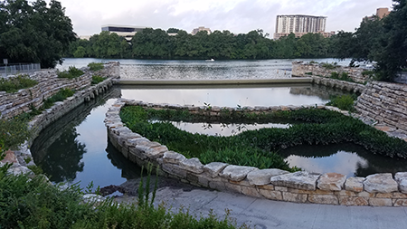
The Waller Creek Tunnel releases floodwaters into Lady Bird Lake at this outlet facility. Take a virtual tour of the Waller Creek Tunnel.
Tunnel Cleaning: January through March 2025
Beginning in January 2025, we will drain water from the tunnel to remove debris and inspect the tunnel. This maintenance occurs every two years and is the only time the tunnel is empty of its 21.8 million gallons of water. We anticipate the work extending into March, but it is highly dependent on the weather.
Visitors to Waller Creek from Waterloo Park to Lady Bird Lake may observe some impacts from this maintenance:
- There will be less water in Waller Creek. Normally, the tunnel pulls water from Lady Bird Lake to keep a steady flow of water in the creek.
- In Waterloo Park, the inlet pond and nearby waterfall will be dry.
- On the Ann and Roy Butler Hike and Bike Trail, there will be flaggers near the Waller Creek Boathouse to direct construction traffic across the trail.
- The outlet facility will be fenced off and there will be construction activity inside. Some of the equipment will make a moderately-loud humming noise.
The tunnel will continue to provide flood protection while it is being cleaned and inspected. Find out more about the tunnel cleaning project.
Tunnel Benefits
- Reduces flood risk to buildings and roads
- Helps revitalize the Waller Creek District
- Allows for reinvestment in parks and trails
- Improves water quality and wildlife habitat in and along Waller Creek
- Provides a constant flow of water in the creek.
Note that the hike and bike trail along the creek is still subject to flooding. Flooding may occur quickly along the trail. Users should be aware of their surroundings and be cautious using the trail in heavy rain.
Waller Creek District
Because of the tunnel, businesses, governments and nonprofits are able to invest in the Waller Creek District. The City of Austin, the Waterloo Greenway Conservancy and the Waller Creek Local Government Corporation created a vision for the district to guide that investment. There are a mix of private and public projects in the works for this district, including 37 acres of parks and open space. Construction on The Confluence, Phase 2 of the Waterloo Greenway, is scheduled to begin in spring 2023. The documents below provide more information on the Waller Creek District:
- Waller Creek Local Government Corporation Progress Report (Fall 2023)
- Waller Creek Corridor Framework Plan
- Waller Creek District Map
For the appendices and other documents associated with the Waller Creek Corridor Framework Plan, look at the backup documents from the November 9, 2015, meeting of the Waller Creek Local Government Corporation.
Operations and Maintenance
The Waller Creek Tunnel is operated by the City of Austin’s Watershed Protection Department. During floods, staff are on hand to remove debris at entrances to the tunnel. Sometimes, the tunnel must be cleaned to remove sediment and debris.
Except during cleanings, the tunnel is almost always full of water. To maintain water quality, fresh water is drawn in from the lake. This provides a system to maintain a constant flow of water in the creek during dry periods.
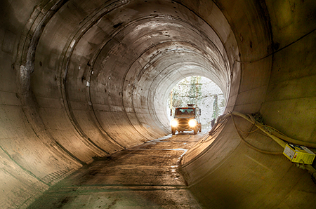
A peak inside the tunnel during construction. The tunnel is usually full of water.
Floodplain Status and Redevelopment
The tunnel significantly reduces flood risk between 12th Street and Lady Bird Lake. Post-tunnel floodplain maps are available at www.ATXFloodPro.com.
Lenders use FEMA’s Flood Insurance Rate Maps to determine the flood risk to buildings and properties. As of September 22, 2022, FEMA's Flood Insurance Rate Maps are effective and reflect the post-tunnel floodplain. Lenders may still require flood insurance despite the information included in the FEMA floodplain maps. Businesses and residents may also choose to keep their flood insurance for the financial protection.