High-Injury Roadways
Austin Transportation’s Vision Zero program identified 13 High-Injury Roadway sections to receive effective, low-cost safety improvements. The Vision Zero team analyzed the most recent five complete years of crash data to identify top locations for focused engineering design initiatives, improved signage, and targeted enforcement on key dangerous driving behaviors.
Over 350 Austinites were seriously injured or killed in the last five years on just these 13 sections. The 13 sections also comprise more than half of the top 100 comprehensive cost locations in Austin, which is based on national guidance to quantify the negative quality of life and economic impacts of crashes on our community. Pursuing low-cost treatments to increase safety will continue to build on the ongoing efforts towards reaching Austin’s Vision Zero goal of eliminating serious injuries and deaths caused by traffic crashes.
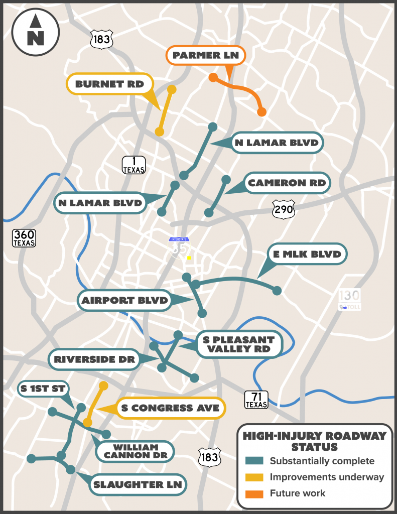
| Airport Boulevard (Manor Road to Springdale Road) | Riverside Drive (Lakeshore Boulevard to Montopolis Drive) |
| Burnet Road (US 183 to MoPac) | South Congress Avenue (Ben White Boulevard to William Cannon Drive) |
| Cameron Road (East St. Johns Avenue to Rundberg Lane) | South Pleasant Valley Road (Cesar Chavez Street to Oltorf Street) |
| East Martin Luther King Jr. Boulevard (Airport Boulevard to Johnny Morris Road) | South First Street (Stassney Lane to Slaughter Lane) |
| North Lamar Boulevard (Koenig Lane to US 183) | Slaughter Lane (Menchaca Road to I-35) |
| North Lamar Boulevard (US 183 to Braker Lane) | William Cannon Drive (Menchaca Road to Elm Creek Drive) |
| Parmer Lane (Metric Boulevard to Dessau Road) |
Updates on High-Injury Roadway sections
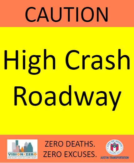
Installation of High-Injury Roadway signage is complete on City roadways, and Austin Transportation has planned and completed improvements on the following sections:
- Airport Boulevard (Manor Road to Springdale Road)
-
- New Flashing Yellow Arrow at Manor Road
- New traffic signal with Flashing Yellow Arrow at Martin Luther King Jr. Boulevard
- New delineators added at Tillery Street
- New channelizers added at East 12th Street
- Added protected-only turn signal phases at Oak Springs Drive
- Added traffic signals with backplates at Oak Springs Drive, Goodwin Avenue and Springdale Road
- Refreshed crosswalk markings at East 12th Street, Oak Springs Drive, Gunter Street, Goodwin Avenue and Kirk Avenue in summer 2021
- Burnet Road (US 183 to MoPac)
-
- Adjusted red light clearance time at MoPac service road
- Refreshed crosswalk markings at Esperanza Crossing in winter 2021 and Kramer Lane, West Braker Lane and Rutland Drive in fall 2022
- Cameron Road (East St. Johns Avenue to Rundberg Lane)
-
- New Flashing Yellow Arrow at East St. Johns Avenue and at McKie Drive/Coronado Hills Drive with leading pedestrian intervals
- Protected-only turn signal phases at East St. Johns Avenue
- New signal battery backups at multiple locations
- Added Leading Pedestrian Interval at Ferguson Lane
- Battery backup system installed at Cross Park Drive
- East Martin Luther King Jr. Boulevard (Airport Boulevard to Johnny Morris Road)
-
- New Flashing Yellow Arrows at E M Franklin Avenue, Tannehill Lane and Johnny Morris Road
- Added protected-only turn signal phases at Tannehill Lane and Johnny Morris Road
- North Lamar Boulevard (US 183 to Braker Lane)
-
- Added Leading Pedestrian Intervals at Thurmond Street, Kramer Lane, Masterson Pass and West Rundberg Lane
- Refreshed crosswalk markings at multiple locations in winter/spring 2021
- New Flashing Yellow Arrow at Thurmond Street, Rutland Drive, Kramer Lane and West Longspur Boulevard
- Extended protected-only turn signal phases at Kramer Lane
- Closed mid-block bus stop in coordination with CapMetro after new stops completed at Powell Lane
- North Lamar Boulevard (Koenig Lane to US 183)
-
- New Flashing Yellow Arrow at West St. Johns Avenue with protected-only turn signal phases and leading pedestrian intervals
- Refreshed crosswalk markings at West St. Johns Avenue in spring 2022
- Added signs at Airport Boulevard to indicate lane assignments for dual left-turn only lanes
- Added Leading Pedestrian Intervals at West Koenig Lane
- Pleasant Valley Road (Cesar Chavez Street to Oltorf Street)
-
- Completed interim safety improvements, including pedestrian hybrid beacons, wider shared-use paths, dedicated turn lanes and new signal infrastructure
- Backplates installed at multiple locations for better signal visibility
- Refreshed crosswalk markings and extended protected-only turn signal phases at South Pleasant Valley and South Lakeshore Boulevard
- New Flashing Yellow Arrow at East Oltorf Street
- New Pedestrian Hybrid Beacon at Sheringham Drive
- New signal battery backups at multiple locations
- Battery backup systems installed at East Cesar Chavez Street and at South Lakeshore Boulevard
- Riverside Drive (Lakeshore Boulevard to Montopolis Drive)
-
- Added Leading Pedestrian Intervals at South Lakeshore Boulevard and at Crossing Place
- Adjusted red light clearance times at Parker Lane/Shore District Drive
- New protected-only turn signal phases at Royal Crest Drive
- New Flashing Yellow Arrows at Faro Drive, Crossing Place and Grove Boulevard.
- Extended protected-only turn at Grove Boulevard
- South Congress Avenue (Ben White Boulevard to William Cannon Drive)
-
- Added Leading Pedestrian Intervals at Radam Lane
- Added ADA-compliant ramps and push buttons, access management improvements at driveways, new signal backplates, and coordinated enhanced bicycle facilities at Sheraton Avenue.
- Refreshed crosswalk markings at Industrial Boulevard and St. Elmo Road in spring 2022.
- South First Street (Stassney Lane to Slaughter Lane)
-
- Added Leading Pedestrian Intervals at West Stassney Lane
- Adjusted red light clearance times at West Dittmar Road
- Refreshed crosswalk markings at West Stassney Lane, Flournoy Drive/Turtle Creek Boulevard and King Edward Place in spring 2022
- Slaughter Lane (Menchaca Road to I-35)
-
- New Flashing Yellow Arrow at Cullen Lane and at Palace Parkway
- Protected-only turn signal phases at Cullen Lane
- Refreshed crosswalk markings at multiple locations in fall 2020
- Battery backup system installed at Talley Lane/United Kingdom Drive
- William Cannon Drive (Menchaca Road to Elm Creek Drive)
-
- New Flashing Yellow Arrow at Woodhue Drive, Cooper Lane and Century South, with protected timing.
- New Flashing Yellow Arrow at Bluff Springs Drive with protected timing for left turns in all directions.
- New Leading Pedestrian Interval at Circle S Road and at Century South.
 |
 |
 |
Engineering improvements
The scope of work will vary for each section depending on current conditions and observed crash patterns. In some locations, Vision Zero is partnering with planned street design work already underway on other City of Austin projects, including multiple 2016 Mobility Bond projects.
Improvements may include:
- New roadway signage
- Traffic signal upgrades, which can include adjusted cycle timing, new or expanded protected left turns, new retroreflective backplates, and new leading pedestrian intervals
- Refreshed roadway markings and crosswalks
- New pedestrian hybrid beacons
- Improved street lighting
- Bus stop relocations
- Other street design changes in partnership with planned or ongoing street design work, including lane conversions, new bicycle facilities, and additional pedestrian crossing opportunities
Selection methodology
To identify the 13 High-Injury Roadway sections, a quantifiable approach based on national guidance was developed to compare crash locations. Through using a consistent standard of comparison, a number of streets were identified where focused efforts might have the biggest impact.
A comprehensive cost scale was used to determine the economic impact of crashes at locations throughout the city, including costs associated with wage and productivity loss of those involved in the crash, medical expenses, motor-vehicle damage employers' uninsured costs and more. This approach does not attempt to put a dollar value on a life, but represents the loss of calculable costs and the loss of quality of life depending on the severity of the injuries resulting from a crash.
After applying a comprehensive cost, crashes were mapped out through GIS so that aggregated comprehensive costs for any particular location could be viewed along with their location. The top comprehensive cost locations were analyzed and 13 sections accounted for over half of the top 100 locations. The 13 sections were selected as High-Injury Roadways.
To learn more about the methodology for High-Injury Roadway identification, read the report.