
About 10% of land in Austin is in the floodplain, subject to the dangers of flash flooding. The Floodplain Office administers local and federal development rules, meant to limit damage and protect lives, and maintains floodplain maps and models.
Austin’s floodplains are the areas likely to flood when our creeks rise and flow over their banks. Every creek and lake has a floodplain, regardless of whether it is mapped or not.
Our office maintains floodplain maps and hydrologic and hydraulic models, administers floodplain regulations, provides information to help protect property from floods and reviews applications to build or remodel in the floodplain. The work we do ensures that Austin is compliant with FEMA rules, protects lives and properties, and allows Austin residents access to more affordable, federally-backed flood insurance.
Floodplain Studies
Floodplains change over time due to changes in our understanding of climate conditions, development, capital improvement projects and other factors. We periodically restudy watersheds to keep pace with such changes.
We have begun the process to update floodplains citywide as a result of the NOAA Atlas 14 study. This study found that Austin is at increased risk for flooding due to heavier rainfall rates. There is more information about this floodplain remapping effort at ATXFloodplains.com.
Floodplain Maps and Atlas 14
The National Weather Service completed a historical rainfall study for Texas in 2018, called Atlas 14. This study shows that Central Texas is experiencing heavier rainfall and that severe flooding is more likely than previously thought. The Atlas 14 study affects many aspects of our flood risk reduction efforts.
The City of Austin, Travis County and other Central Texas communities are updating floodplain maps in the region based on the Atlas 14 study. Our current floodplain maps show where flooding is likely to occur with 10.2 inches of rainfall in 24 hours. The updated maps will reflect flooding from almost 13 inches of rain in some areas. This amount of rainfall has a one percent chance of occurring in any given year (the 100-year storm). Find out more about floodplain remapping efforts at ATXFloodplains.com.
Is Your Austin Property Affected?
The City of Austin’s floodplain maps are available online. Maps default to show the floodplain used to regulate development, called the fully developed floodplain. Pending completion of the City’s ongoing floodplain study updates, the regulatory floodplain is based on the current FEMA 500-year floodplain. To view floodplain maps, follow the instructions below or download these instructions:
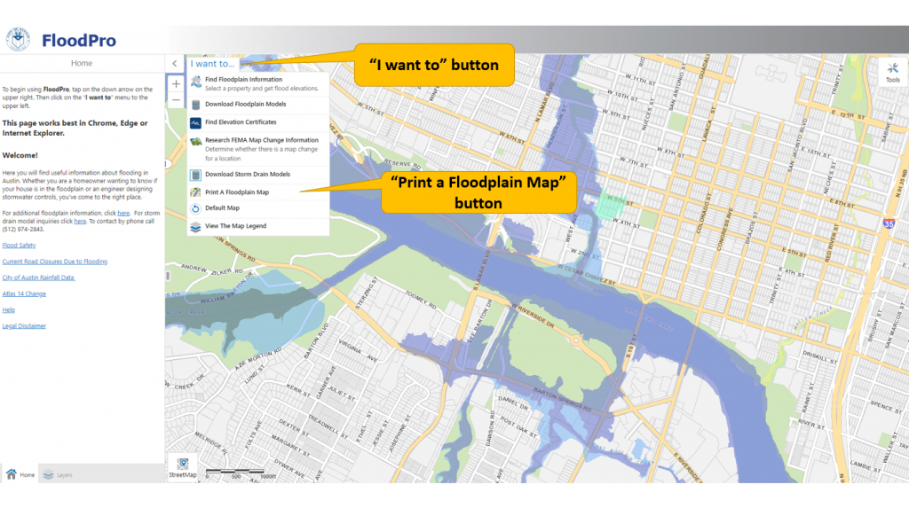
- Go to ATXFloodPro.com.
- Click the "I want to" button, then "Find Floodplain Information"
- Enter your address and click on "Search."
- Areas shown in light blue are in the fully developed floodplain and subject to floodplain regulations. Areas shown in darker blue are subject to stricter regulations.
- To print or download a map of your property, click the "I want to" button again and select "Print a Floodplain Map." Check the circle next to "COA Map." Click “Print” and wait for your map to be created. Then, click “Download your map” to save the map file. Choosing "Print Current" will prepare a map of the area you are currently zoomed in to.
Learn More
- What is the 100-year floodplain?
-
Depending on how much rain there’s been, Austin’s creeks may be bone dry, gently flowing with water or a raging torrent. The floodplain is the area of land that is likely to be under water when the creek rushes over its banks. In a sense, the floodplain is the full extension of the creek.
The 100-year floodplain is the land that is predicted to flood during a 100-year storm, which has a 1% chance of occurring in any given year. You may also hear the 100-year floodplain called the 1% annual chance floodplain or base flood. Areas within the 100-year floodplain may flood in much smaller storms as well. The 100-year floodplain is used by FEMA to administer the federal flood insurance program and the City of Austin to regulate development.
- How does a drainage easement impact what I can do on my property?
-
A drainage easement is a part of your property where the City has limited rights of access and/or use. Generally, you cannot make any improvements in a drainage easement. That means no fences, sheds, walls, trails or buildings. You should avoid planting trees or much landscaping as well.
A drainage easement has two possible purposes. It may be needed for the flow of storm water. For example, storm drains, drainage ditches and creeks are typically within a drainage easement. In this case, anything that prevents the flow of water; that might catch debris; that might be washed away; or that might cause a dam-like effect is problematic.
Alternatively, the easement may be needed to access drainage infrastructure. In this case, anything that might make it difficult to drive a truck through or dig up an underground pipe is problematic.
- Updated floodplain regulations
-
In November 2019, the city updated its floodplain regulations in response to the NOAA Atlas 14 study. These regulations provide rules for constructing and remodeling buildings and developing property in the floodplain. The rules help protect the public from flooding and reduce public expense in the aftermath of a flood.
The floodplain rules apply when you are building, redeveloping or remodeling in the floodplain. If you are simply living in your home or running your business, you do not need to make any changes to comply. The most significant change is to base development regulations on the current FEMA 500-year floodplain, instead of the 100-year floodplain. The 500-year floodplain is larger, based on heavier rainfall, and better reflects Austin’s risk of flooding as revealed in the Atlas 14 study. Making this change gives us time to update our floodplain maps to reflect the Atlas 14 information. It helps prevent new houses and businesses from being built or significantly improved in flood-prone areas while the floodplain maps are updated.
There were also changes to the process to get a permit in the floodplain to redevelop or remodel residential properties. When the redevelopment or remodeling meet specific requirements for making the property safer from flooding, City staff can now approve the permit instead of seeking approval from the Austin City Council. There were also changes to the specifics of how high a building needs to be elevated above the regulatory flood elevation.
- Commercial redevelopment
-
On September 1, 2022, the Austin City Council approved a code revision regarding commercial redevelopment in the floodplain. The change makes it easier to redevelop a commercial property when the changes make the building safer from flooding and do not significantly increase occupancy of the building. This code revision is similar to the provision for residential properties that went into effect in 2019.
- In-depth FEMA documents available for download
Request Information and Assistance
Our staff is available to meet with you to discuss your situation and strategies for reducing damages. You can contact the department by phone or email.
- Phone: Please call 512-974-2843 and leave a message when prompted. A member of our staff will call you back.
- Email: Send an Email to FloodPro.